|
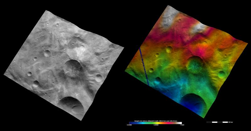
Apparent Brightness and Topography Images of Antonia Crater
- Click the image above for a larger view
- Full-Res JPEG (3450 x 1800) (374.9 kB)
- Full-Res TIFF (3450 x 1800) (18.6 MB)
Caption:
The left-hand image is a Dawn FC (framing camera) image, which shows the apparent brightness of Vesta's surface. The right-hand image is based on this apparent brightness image, which has had a color-coded height representation of the topography overlain onto it. The topography is calculated from a set of images that were observed from different viewing directions, which allows stereo reconstruction. The various colors correspond to the height of the area. The white and red areas in the topography image are the highest areas and the blue areas are the lowest areas. Antonia crater is the relatively large crater offset to the right of the center of the image. The top rim of Antonia crater is reasonably fresh and the bottom rim is relatively degraded. In the topography image it is clear that the side of the crater with the more degraded rim has a shallow slope because it is only color-coded in one color: green. The opposite side has a much steeper slope because it is color-coded in many colors. The degraded rim and shallower slope on one side of the crater are thought to have been formed by a landslide or a similar process.
These images are located in Vesta's Tuccia quadrangle, in Vesta's southern hemisphere. NASA's Dawn spacecraft obtained the brightness image with its framing camera on Oct. 24, 2011. This image was taken through the camera's clear filter. The distance to the surface of Vesta is 700 kilometers (435 miles) and the image has a resolution of about 70 meters (230 feet) per pixel. This image was acquired during the HAMO (high-altitude mapping orbit) phase of the mission. These images are lambert-azimuthal map projected.
Background Info:
The Dawn mission to Vesta and Ceres is managed by NASA's Jet Propulsion Laboratory, a division of the California Institute of Technology in Pasadena, for NASA's Science Mission Directorate, Washington D.C. UCLA is responsible for overall Dawn mission science. The Dawn framing cameras have been developed and built under the leadership of the Max Planck Institute for Solar System Research, Katlenburg-Lindau, Germany, with significant contributions by DLR German Aerospace Center, Institute of Planetary Research, Berlin, and in coordination with the Institute of Computer and Communication Network Engineering, Braunschweig. The framing camera project is funded by the Max Planck Society, DLR, and NASA/JPL.
More information about Dawn is online at http://www.nasa.gov/dawn and http://dawn.jpl.nasa.gov .
Cataloging Keywords:
| Name | Value | Additional Values |
|---|---|---|
| Target | 4 Vesta | |
| System | Main Belt | |
| Target Type | Asteroid | |
| Mission | Dawn | |
| Instrument Host | Dawn | |
| Host Type | Orbiter | |
| Instrument | Framing Camera (FC) | |
| Detector | ||
| Extra Keywords | Color, Crater, Map | |
| Acquisition Date | ||
| Release Date | 2012-06-12 | |
| Date in Caption | 2011-10-24 | |
| Image Credit | NASA/JPL-Caltech/UCLA/MPS/DLR/IDA | |
| Source | photojournal.jpl.nasa.gov/catalog/PIA15796 | |
| Identifier | PIA15796 | |