|
Topographic Map of Curiosity Landing Area
- Click the image above for a larger view
- Full-Res JPEG (3300 x 2550) (2.2 MB)
- Full-Res TIFF (3300 x 2550) (25.3 MB)
Caption:
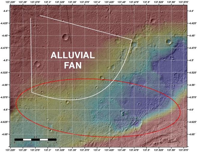
This image shows the topography, with shading added, around the area where NASA's Curiosity rover is slated to land on Aug. 5 PDT (Aug. 6 EDT). Red indicates higher areas and purple indicates lower areas, with a total elevation range of about 600 feet (nearly 200 meters). The red oval indicates the targeted landing area for the rover known as the "landing ellipse." An annotation indicates the location of an alluvial fan, or a fan-shaped deposit where debris spreads out downslope. On Earth, alluvial fans often are formed by flowing water. The presence of channel-like features in the Gale Crater fan suggest a similar origin.
Elevation data were obtained from stereo processing of images from the High Resolution Imaging Science Experiment (HiRISE) camera on NASA's Mars Reconnaissance Orbiter.
Thermal inertia data are from the Thermal Emission Spectrometer (THEMIS) onboard NASA's Odyssey.
Background Info:
NASA's Jet Propulsion Laboratory, a division of the California Institute of Technology, in Pasadena, manages the Mars Science Laboratory mission for the NASA Science Mission Directorate, Washington, and built Curiosity.
Cataloging Keywords:
| Name | Value | Additional Values |
|---|---|---|
| Target | Mars | |
| System | ||
| Target Type | Planet | |
| Mission | Mars Science Laboratory (MSL) | Mars Reconnaissance Orbiter (MRO) |
| Instrument Host | Curiosity Rover | Mars Reconnaissance Orbiter |
| Host Type | Rover | Orbiter |
| Instrument | ||
| Detector | ||
| Extra Keywords | Color, Crater, Map, Thermal, Water | |
| Acquisition Date | ||
| Release Date | 2012-08-02 | |
| Date in Caption | ||
| Image Credit | NASA/JPL-Caltech/UofA/USGS/ASU | |
| Source | photojournal.jpl.nasa.gov/catalog/PIA15956 | |
| Identifier | PIA15956 | |