
|
Mars Weather Map, Aug. 2, 2012
- Click the image above for a larger view
- Full-Res JPEG (3258 x 1817) (500.2 kB)
- Full-Res TIFF (3258 x 1817) (17.8 MB)
Caption:
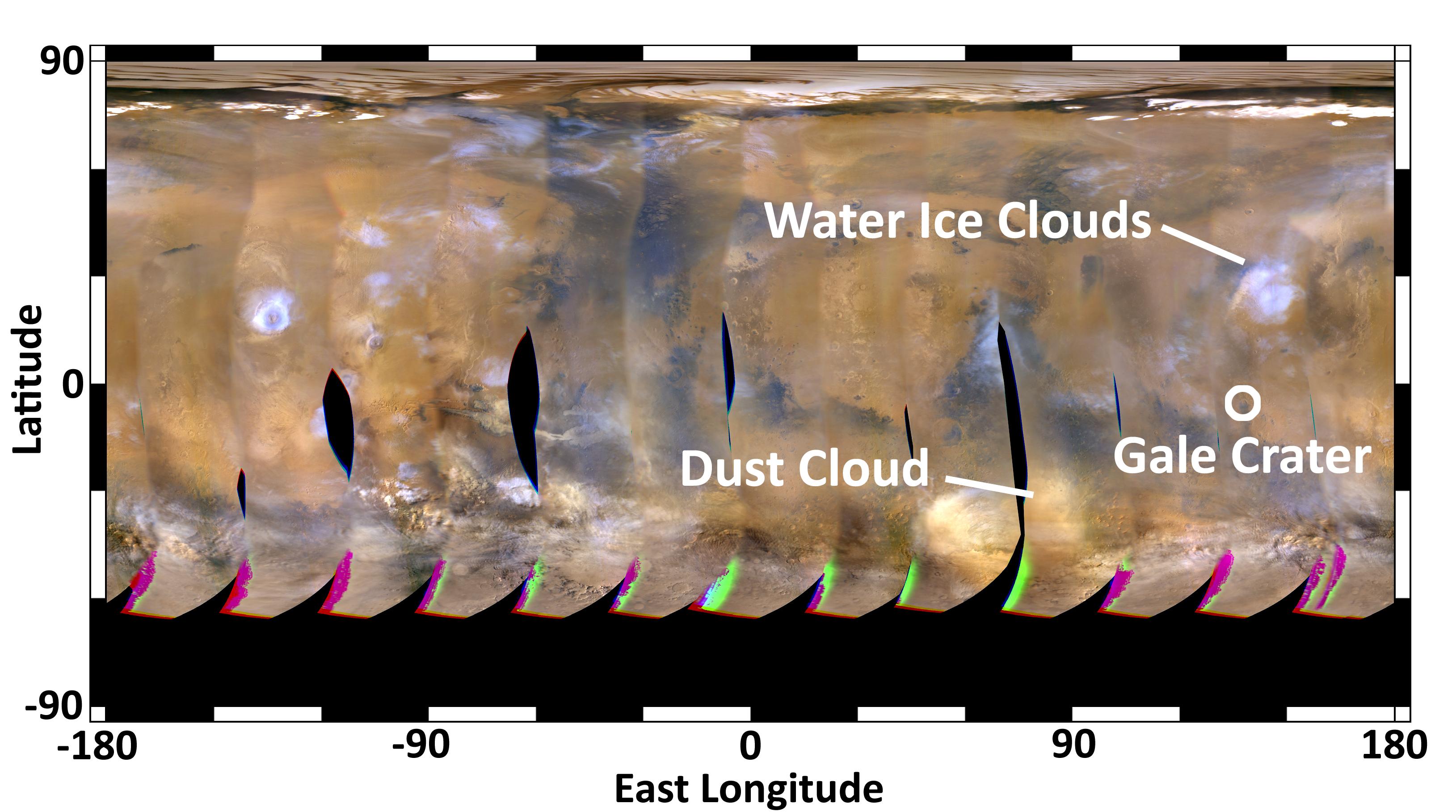
This global map of Mars was acquired on Aug. 2, 2012, by the Mars Color Imager instrument on NASA's Mars Reconnaissance Orbiter. One global map is generated each day to forecast weather conditions for the entry, descent and landing of NASA's Curiosity rover. The active dust storm observed south of Curiosity's landing site on July 31 has dissipated, leaving behind a dust cloud that will not pose a threat to the landing.
The map is a rectangular projection of Mars (from 90 degrees latitude to minus 90 degrees latitude, and minus 180 degrees longitude to 180 degrees east longitude). The landing site is located on the right side of the map, near 137 degrees east longitude and 4.5 degrees south latitude. The map shows water ice clouds at equatorial latitudes that are typical for late southern winter, when Mars is farther from the sun. Along the southern (bottom) part of the map there are patches of orange clouds, indicating dust lofted into the atmosphere. Small, short-lived dust storms are common at this time of year on Mars and were taken into account when Curiosity's landing system was designed and tested. Larger and more long-lived dust storms are very rare at this time of year.
Cataloging Keywords:
| Name | Value | Additional Values |
|---|---|---|
| Target | Mars | |
| System | ||
| Target Type | Planet | |
| Mission | Mars Reconnaissance Orbiter (MRO) | Mars Science Laboratory (MSL) |
| Instrument Host | Mars Reconnaissance Orbiter | Curiosity Rover |
| Host Type | Orbiter | Rover |
| Instrument | Mars Color Imager (MARCI) | |
| Detector | ||
| Extra Keywords | Atmosphere, Color, Dust, Map, Storm, Water | |
| Acquisition Date | ||
| Release Date | 2012-08-04 | |
| Date in Caption | 2012-08-02 | |
| Image Credit | NASA/JPL-Caltech/MSSS | |
| Source | photojournal.jpl.nasa.gov/catalog/PIA15962 | |
| Identifier | PIA15962 | |