skip to navigation

|
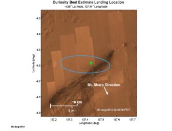
Where Curiosity Landed on Mars
- Click the image above for a larger view
- Full-Res JPEG (1575 x 1200) (148.8 kB)
- Full-Res TIFF (1575 x 1200) (5.7 MB)
Caption:
The green diamond shows approximately where NASA's Curiosity rover landed on Mars, a region about 2 kilometers northeast of its target in the center of the estimated landing region (blue ellipse). The location of the diamond is based on Earth-based navigation data taken prior to Curiosity's entry into the Martian atmosphere, as well as data taken by the rover's navigation instruments during descent.
Cataloging Keywords:
| Name | Value | Additional Values |
|---|---|---|
| Target | Mars | |
| System | ||
| Target Type | Planet | |
| Mission | Mars Science Laboratory (MSL) | |
| Instrument Host | Curiosity Rover | |
| Host Type | Rover | |
| Instrument | ||
| Detector | ||
| Extra Keywords | Atmosphere, Color | |
| Acquisition Date | ||
| Release Date | 2012-08-06 | |
| Date in Caption | ||
| Image Credit | NASA/JPL-Caltech | |
| Source | photojournal.jpl.nasa.gov/catalog/PIA15981 | |
| Identifier | PIA15981 | |
