
|
Opportunity’s Surroundings on 3,000th Sol
- Click the image above for a larger view
- Full-Res JPEG (7688 x 987) (1.1 MB)
- Full-Res TIFF (7688 x 987) (7.6 MB)
Caption:
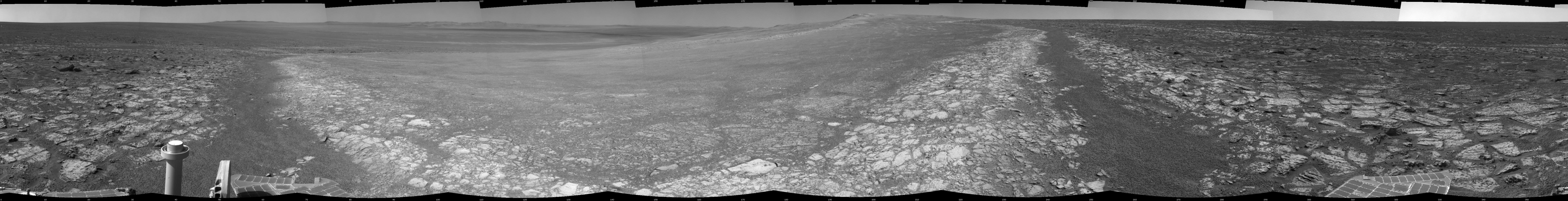
This 360-degree panorama assembled from images taken by the navigation camera on NASA's Mars Exporation Rover Opportunity shows terrain surrounding the position where the rover spent its 3,000th Martian day, or sol, working on Mars (July 2, 2012). Opportunity completed its 90-sol prime mission in April 2004. It has continued to explore the Meridiani Planum region of Mars for more than eight years of bonus extended missions.
The Sol 3000 site is near the northern tip of the Cape York segment of the western rim of Endeavour Crater. Bright toned material lines the perimeter of Cape York.
This panoramic view is centered to the south, with north at both ends. The component images were taken during sols 2989 through 2991.
Opportunity arrived at this location on Sol 2989 (June 20, 2012) with a drive bringing the mission's total driving distance as of Sol 3000 to 21.432 miles (34,492 meters). Here it examined a rock target called "Grasberg" with its microscopic imager and alpha particle X-ray spectrometer, both before and after grinding the surface off the target with the rover's rock abrasion tool. Opportunity departed this location with an eastward drive of about 105 feet (32 meters) on Sol 3008 (July 10, 2012).
The scene is presented as a cylindrical projection in this image.
Cataloging Keywords:
| Name | Value | Additional Values |
|---|---|---|
| Target | Mars | |
| System | ||
| Target Type | Planet | |
| Mission | Mars Exploration Rover (MER) | |
| Instrument Host | Opportunity (MER-B) | |
| Host Type | Rover | |
| Instrument | Navigation Camera (Navcam) | |
| Detector | ||
| Extra Keywords | Crater, Grayscale | |
| Acquisition Date | ||
| Release Date | 2012-09-07 | |
| Date in Caption | 2012-06-20 | 2012-07-02, 2012-07-10 |
| Image Credit | NASA/JPL-Caltech | |
| Source | photojournal.jpl.nasa.gov/catalog/PIA16122 | |
| Identifier | PIA16122 | |