|
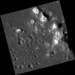
Hawaiian Hollows
- Click the image above for a larger view
- Full-Res JPEG (1248 x 1249) (98.6 kB)
- Full-Res TIFF (1248 x 1249) (1.6 MB)
Caption:
This close-up image of the central peaks of Velazquez crater bears a striking resemblance to the Hawaiian islands. The tops of these peaks are covered by hollows .
This image was acquired as a high-resolution targeted observation. Targeted observations are images of a small area on Mercury's surface at resolutions much higher than the 200-meter/pixel morphology base map. It is not possible to cover all of Mercury's surface at this high resolution, but typically several areas of high scientific interest are imaged in this mode each week.
Date acquired:
October 17, 2012
Image Mission Elapsed Time (MET):
258976725
Image ID:
2782780
Instrument:
Narrow Angle Camera (NAC) of the Mercury Dual Imaging System (MDIS)
Center Latitude:
37.17°
Center Longitude:
304.5° E
Resolution:
20 meters/pixel
Scale:
This image is 21 kilometers (13 miles) across.
Incidence Angle:
71.1°
Emission Angle:
3.0°
Phase Angle:
68.0°
Background Info:
The MESSENGER spacecraft is the first ever to orbit the planet Mercury, and the spacecraft's seven scientific instruments and radio science investigation are unraveling the history and evolution of the Solar System's innermost planet. Visit the Why Mercury? section of this website to learn more about the key science questions that the MESSENGER mission is addressing. During the one-year primary mission, MDIS acquired 88,746 images and extensive other data sets. MESSENGER is now in a year-long extended mission, during which plans call for the acquisition of more than 80,000 additional images to support MESSENGER's science goals.
These images are from MESSENGER, a NASA Discovery mission to conduct the first orbital study of the innermost planet, Mercury. For information regarding the use of images, see the MESSENGER image use policy .
Cataloging Keywords:
| Name | Value | Additional Values |
|---|---|---|
| Target | Mercury | |
| System | ||
| Target Type | Planet | |
| Mission | MESSENGER | |
| Instrument Host | MESSENGER | |
| Host Type | Orbiter | |
| Instrument | Mercury Dual Imaging System (MDIS) | |
| Detector | Narrow Angle Camera (NAC) | |
| Extra Keywords | Crater, Grayscale, Map, Radio | |
| Acquisition Date | ||
| Release Date | 2012-11-04 | |
| Date in Caption | 2012-10-17 | |
| Image Credit | NASA/Johns Hopkins University Applied Physics Laboratory/Carnegie Institution of Washington | |
| Source | photojournal.jpl.nasa.gov/catalog/PIA16304 | |
| Identifier | PIA16304 | |
