|
Let’s Get Some Perspective Here!
- Click the image above for a larger view
- Full-Res JPEG (1024 x 1024) (250.1 kB)
- Full-Res TIFF (1024 x 1024) (3.1 MB)
Caption:
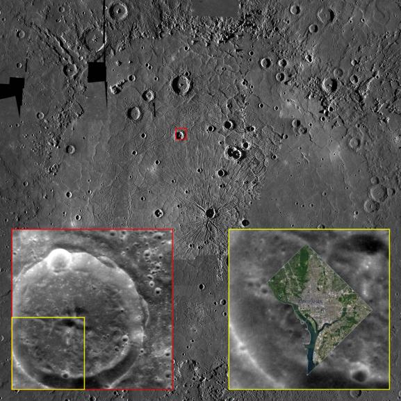
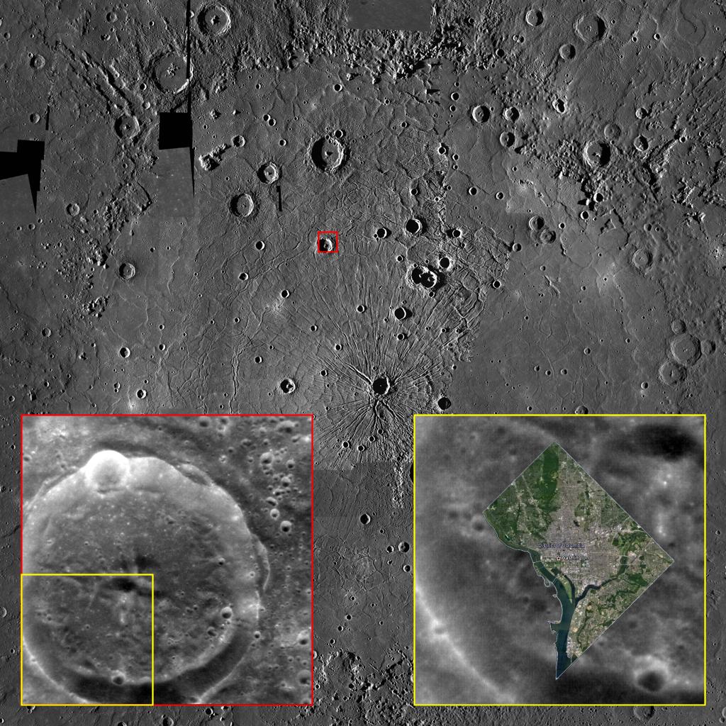
Although Mercury is the smallest of the four terrestrial planets in the Solar System, its surface area is approximately half that of all the land surface on Earth. So there is a lot of room for the innermost planet's variety of craters , tectonic landforms , smooth plains , hollows , and myriad other interesting features .
It is therefore quite possible to lose sight, despite its small size, of just how big many features on Mercury are. This image shows a photomosaic of the mighty Caloris basin , with a much smaller, unnamed crater in its northwestern quadrant highlighted with a small red box. The bottom left inset, outlined in red, shows a NAC high-resolution image of this same crater -- and the bottom right inset, outlined in yellow, shows how the entirety of Washington, D.C. fits comfortably into the area between that crater's central peak and its rim! The District of Columbia forms a partial diamond that is 16 km (10 mi.) on a side, or approx. 22 km (14 mi.) from north to south, and is home to over 600,000 people. In fact, Caloris is so big that the entire state of Texas could fit within its perimeter.
So, although Mercury may be the smallest terrestrial world we know of, it's still a pretty big place!
The image in the insert was acquired as a high-resolution targeted observation. Targeted observations are images of a small area on Mercury's surface at resolutions much higher than the 200-meter/pixel morphology base map. It is not possible to cover all of Mercury's surface at this high resolution, but typically several areas of high scientific interest are imaged in this mode each week.
MAIN IMAGE:
Date Created:
August 29, 2012
Instrument:
Mercury Dual Imaging System (MDIS)
Latitude Range:
12° N to 52° N
Longitude Range:
139° E to 187° E
Resolution:
1,720 meters/pixel
Scale:
Caloris basin is approx. 1,550 km (960 mi.) in diameter
Projection:
Azimuthal equidistant
BOTTOM-LEFT INSET:
Date acquired:
July 03, 2011
Image Mission Elapsed Time (MET):
218161324
Image ID:
456305
Instrument:
Narrow Angle Camera (NAC) of the Mercury Dual Imaging System (MDIS)
Center Latitude:
38.62°
Center Longitude:
159.41° E
Resolution:
100 meters/pixel
Scale:
This crater is approx. 39 km (24 mi.) in diameter
Incidence Angle:
38.6°
Emission Angle:
3.1°
Phase Angle:
39.3°
Note: North is to the top in all images.
Background Info:
The MESSENGER spacecraft is the first ever to orbit the planet Mercury, and the spacecraft's seven scientific instruments and radio science investigation are unraveling the history and evolution of the Solar System's innermost planet. Visit the Why Mercury? section of this website to learn more about the key science questions that the MESSENGER mission is addressing. During the one-year primary mission, MDIS acquired 88,746 images and extensive other data sets. MESSENGER is now in a year-long extended mission, during which plans call for the acquisition of more than 80,000 additional images to support MESSENGER's science goals.
These images are from MESSENGER, a NASA Discovery mission to conduct the first orbital study of the innermost planet, Mercury. For information regarding the use of images, see the MESSENGER image use policy .
Cataloging Keywords:
| Name | Value | Additional Values |
|---|---|---|
| Target | Mercury | |
| System | ||
| Target Type | Planet | |
| Mission | MESSENGER | |
| Instrument Host | MESSENGER | |
| Host Type | Orbiter | |
| Instrument | Mercury Dual Imaging System (MDIS) | |
| Detector | Narrow Angle Camera (NAC) | |
| Extra Keywords | Color, Crater, Map, Radio | |
| Acquisition Date | ||
| Release Date | 2012-08-31 | |
| Date in Caption | 2011-07-03 | 2012-08-29 |
| Image Credit | NASA/Johns Hopkins University Applied Physics Laboratory/Carnegie Institution of Washington | |
| Source | photojournal.jpl.nasa.gov/catalog/PIA16394 | |
| Identifier | PIA16394 | |