
|
Polar Topography
- Click the image above for a larger view
- Full-Res JPEG (1280 x 720) (264.2 kB)
- Full-Res TIFF (1280 x 720) (2.8 MB)
Caption:
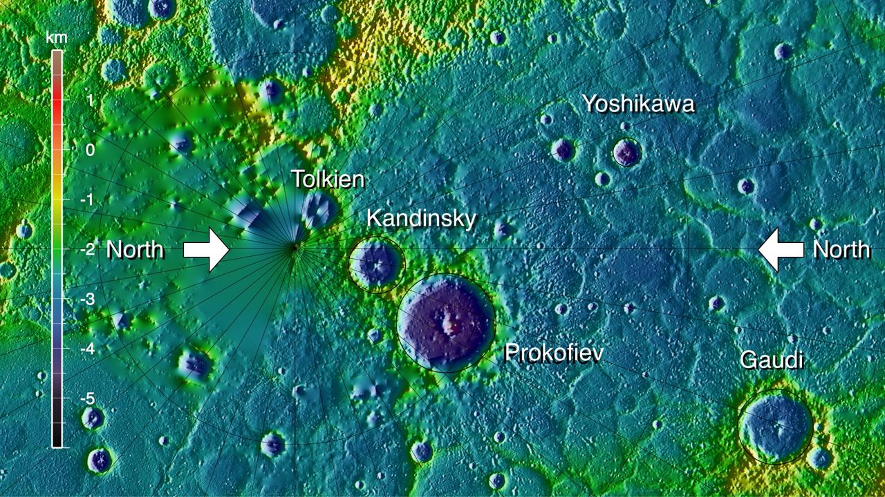
Topography of a portion of Mercury from 75°N northward to the pole, in shaded relief and color-coded by elevation. The map is centered at 85°N on the 110-km-diameter crater Prokofiev , whose interior lies more than 5 km below the topographic datum. The north pole lies to the left of and below the smaller craters Tolkien and Kandinsky. Because of the inclination of MESSENGER's orbit, ranging measurements poleward of 83-84°N require spacecraft maneuvers and oblique viewing. Most of the area north of these latitudes has been sparsely covered by MLA to date and is either seldom illuminated by sunlight or lies in permanent shadow.
Instrument: Mercury Laser Altimeter (MLA)
Background Info:
The MESSENGER spacecraft is the first ever to orbit the planet Mercury, and the spacecraft's seven scientific instruments and radio science investigation are unraveling the history and evolution of the Solar System's innermost planet. Visit the Why Mercury? section of this website to learn more about the key science questions that the MESSENGER mission is addressing. During the one-year primary mission, MDIS acquired 88,746 images and extensive other data sets. MESSENGER is now in a year-long extended mission, during which plans call for the acquisition of more than 80,000 additional images to support MESSENGER's science goals.
For information regarding the use of images, see the MESSENGER image use policy .
Cataloging Keywords:
| Name | Value | Additional Values |
|---|---|---|
| Target | Mercury | |
| System | ||
| Target Type | Planet | |
| Mission | MESSENGER | |
| Instrument Host | MESSENGER | |
| Host Type | Orbiter | |
| Instrument | Mercury Laser Altimeter (MLA) | |
| Detector | ||
| Extra Keywords | Color, Crater, Map, Radio, Shadow | |
| Acquisition Date | ||
| Release Date | 2012-11-29 | |
| Date in Caption | ||
| Image Credit | NASA/Johns Hopkins University Applied Physics Laboratory/Carnegie Institution of Washington | |
| Source | photojournal.jpl.nasa.gov/catalog/PIA16516 | |
| Identifier | PIA16516 | |