|
Modeling Ice Stability
- Click the image above for a larger view
- Full-Res JPEG (1280 x 720) (98.8 kB)
- Full-Res TIFF (1280 x 720) (2.8 MB)
Caption:
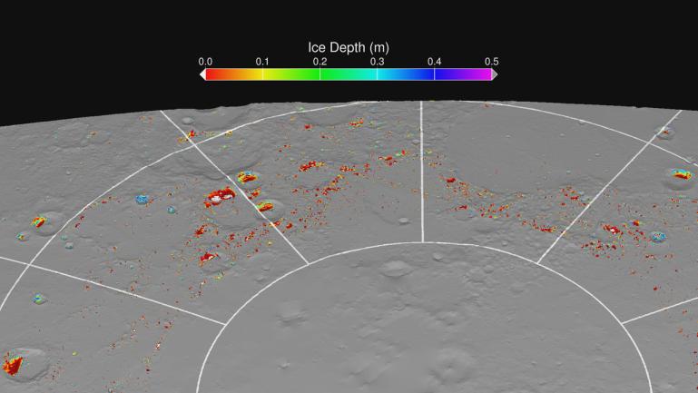
A map of "permafrost" on Mercury showing the calculated depths below the surface at which water ice is predicted to be thermally stable. The grey areas are regions that are too warm at all depths for stable water ice. The colored regions are sufficiently cold for subsurface ice to be stable, and the white regions are sufficiently cold for exposed surface ice to be stable. The thermal model results predict the presence of surface and subsurface water ice at the same locations where they are observed by Earth-based radar and MLA observations .
Instrument: Mercury Laser Altimeter (MLA)
Background Info:
The MESSENGER spacecraft is the first ever to orbit the planet Mercury, and the spacecraft's seven scientific instruments and radio science investigation are unraveling the history and evolution of the Solar System's innermost planet. Visit the Why Mercury? section of this website to learn more about the key science questions that the MESSENGER mission is addressing. During the one-year primary mission, MDIS acquired 88,746 images and extensive other data sets. MESSENGER is now in a year-long extended mission, during which plans call for the acquisition of more than 80,000 additional images to support MESSENGER's science goals.
For information regarding the use of images, see the MESSENGER image use policy .
Cataloging Keywords:
| Name | Value | Additional Values |
|---|---|---|
| Target | Mercury | |
| System | ||
| Target Type | Planet | |
| Mission | MESSENGER | |
| Instrument Host | MESSENGER | |
| Host Type | Orbiter | |
| Instrument | Mercury Laser Altimeter (MLA) | |
| Detector | ||
| Extra Keywords | Color, Map, Radar, Radio, Thermal, Water | |
| Acquisition Date | ||
| Release Date | 2012-11-29 | |
| Date in Caption | ||
| Image Credit | NASA/Johns Hopkins University Applied Physics Laboratory/Carnegie Institution of Washington | |
| Source | photojournal.jpl.nasa.gov/catalog/PIA16521 | |
| Identifier | PIA16521 | |