
|
Titan Wetlands
- Click the image above for a larger view
- Full-Res JPEG (1226 x 441) (118.8 kB)
- Full-Res TIFF (1226 x 441) (1.6 MB)
Caption:

Annotated Version
Click on the image for larger version
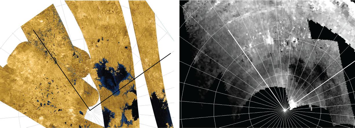
A dense network of small rivers or swampy areas appears to connect some of the seas on Saturn's moon Titan, as seen in this comparison of data of the same area from two instruments on NASA's Cassini spacecraft. Images from the radar instrument are on the left and images from the visual and infrared mapping spectrometer (VIMS) are on the right.
At approximately 50,000 square miles (about 125,000 square kilometers), Ligeia Mare (middle of the images) is larger than any North American lake. The labels K1, K2, and K3 in the radar mosaic (a) refer to different parts of Kraken Mare that appear interconnected in the VIMS mosaic (b).
Background Info:
The Cassini-Huygens mission is a cooperative project of NASA, the European Space Agency and the Italian Space Agency. The Jet Propulsion Laboratory, a division of the California Institute of Technology in Pasadena, manages the mission for NASA's Science Mission Directorate, Washington, D.C. The Cassini orbiter was designed, developed and assembled at JPL. The visual and infrared mapping spectrometer team is based at the University of Arizona, Tucson. The radar instrument was built by JPL and the Italian Space Agency, working with team members from the United States and several European countries.
For more information on Cassini, visit http://www.nasa.gov/cassini and http://saturn.jpl.nasa.gov .
Cataloging Keywords:
| Name | Value | Additional Values |
|---|---|---|
| Target | Titan | |
| System | Saturn | |
| Target Type | Satellite | |
| Mission | Cassini-Huygens | |
| Instrument Host | Cassini Orbiter | |
| Host Type | Orbiter | |
| Instrument | Radar Mapper | Visual and Infrared Mapping Spectrometer (VIMS) |
| Detector | ||
| Extra Keywords | Color, Infrared, Radar, Visual | |
| Acquisition Date | ||
| Release Date | 2013-04-15 | |
| Date in Caption | ||
| Image Credit | NASA/JPL-Caltech/University of Arizona | |
| Source | photojournal.jpl.nasa.gov/catalog/PIA16845 | |
| Identifier | PIA16845 | |