|
The Pit
- Click the image above for a larger view
- Full-Res JPEG (1629 x 1455) (196.1 kB)
- Full-Res TIFF (1629 x 1455) (2.4 MB)
Caption:
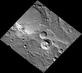
These unnamed craters are located northeast of Magritte crater, in Mercury's southeastern hemisphere. The floor of the crater just south of the center of the image is scarred by irregularly shaped pits . The spectral measurements of these pits indicate that the pitted crater is much redder than the surrounding terrain, suggesting that it may be associated with pyroclastic material.
This image was acquired as part of MDIS's high-resolution stereo imaging campaign. Images from the stereo imaging campaign are used in combination with the surface morphology base map or the albedo base map to create high-resolution stereo views of Mercury's surface, with an average resolution of 200 meters/pixel. Viewing the surface under the same Sun illumination conditions but from two or more viewing angles enables information about the small-scale topography of Mercury's surface to be obtained.
Date acquired:
December 05, 2011
Image Mission Elapsed Time (MET):
231614646
Image ID:
1099397
Instrument:
Narrow Angle Camera (NAC) of the Mercury Dual Imaging System (MDIS)
Center Latitude:
-64.76°
Center Longitude:
146.5° E
Resolution:
163 meters/pixel
Scale:
The largest crater in this image is roughly 74 km (46 mi.) across.
Incidence Angle:
69.2°
Emission Angle:
26.6°
Phase Angle:
86.5°
Background Info:
The MESSENGER spacecraft is the first ever to orbit the planet Mercury, and the spacecraft's seven scientific instruments and radio science investigation are unraveling the history and evolution of the Solar System's innermost planet. MESSENGER acquired over 150,000 images and extensive other data sets. MESSENGER is capable of continuing orbital operations until early 2015.
For information regarding the use of images, see the MESSENGER image use policy .
Cataloging Keywords:
| Name | Value | Additional Values |
|---|---|---|
| Target | Mercury | |
| System | ||
| Target Type | Planet | |
| Mission | MESSENGER | |
| Instrument Host | MESSENGER | |
| Host Type | Orbiter | |
| Instrument | Mercury Dual Imaging System (MDIS) | |
| Detector | Narrow Angle Camera (NAC) | |
| Extra Keywords | Crater, Grayscale, Map, Radio | |
| Acquisition Date | ||
| Release Date | 2013-06-07 | |
| Date in Caption | 2011-12-05 | |
| Image Credit | NASA/Johns Hopkins University Applied Physics Laboratory/Carnegie Institution of Washington | |
| Source | photojournal.jpl.nasa.gov/catalog/PIA17237 | |
| Identifier | PIA17237 | |
