|
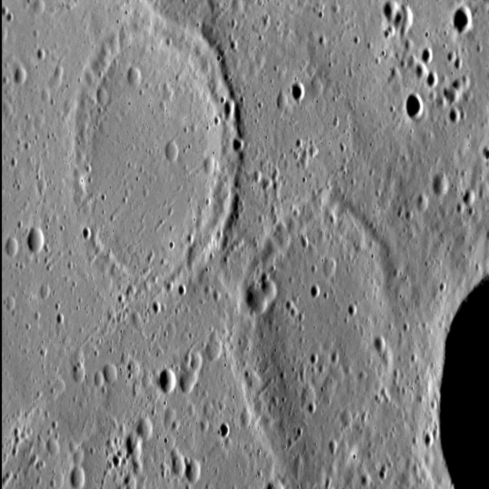
A Tale of Two Craters
- Click the image above for a larger view
- Full-Res JPEG (1024 x 1024) (148.1 kB)
- Full-Res TIFF (1024 x 1024) (1.1 MB)
Caption:
Approximately 27% of Mercury's surface is classified as " smooth plains ," the majority of which are interpreted to be volcanic in origin. One of the characteristics of volcanic resurfacing is the infilling by lava of pre-existing craters. In some cases, volcanism partially covers a crater, leaving the original rim visible. Often, however, lava will completely bury a crater, and only subsequent tectonic deformation (through the formation of wrinkle ridges ) shows us the location of these buried -- or ghost -- craters.
This image was acquired as a high-resolution targeted observation. Targeted observations are images of a small area on Mercury's surface at resolutions much higher than the 200-meter/pixel morphology base map. It is not possible to cover all of Mercury's surface at this high resolution, but typically several areas of high scientific interest are imaged in this mode each week.
Date acquired:
July 3, 2013
Image Mission Elapsed Time (MET):
15164506
Image ID:
4372034
Instrument:
Narrow Angle Camera (NAC) of the Mercury Dual Imaging System (MDIS)
Center Latitude:
33.8°
Center Longitude:
3.5° E
Resolution:
31 meters/pixel
Scale:
The top-left crater is approximately 18 km (11.2 mi.) in north-south diameter
Incidence Angle:
75.3°
Emission Angle:
53.9°
Phase Angle:
129.2°
North is down in this image.
Background Info:
The MESSENGER spacecraft is the first ever to orbit the planet Mercury, and the spacecraft's seven scientific instruments and radio science investigation are unraveling the history and evolution of the Solar System's innermost planet. MESSENGER acquired over 150,000 images and extensive other data sets. MESSENGER is capable of continuing orbital operations until early 2015.
For information regarding the use of images, see the MESSENGER image use policy .
Cataloging Keywords:
| Name | Value | Additional Values |
|---|---|---|
| Target | Mercury | |
| System | ||
| Target Type | Planet | |
| Mission | MESSENGER | |
| Instrument Host | MESSENGER | |
| Host Type | Orbiter | |
| Instrument | Mercury Dual Imaging System (MDIS) | |
| Detector | Narrow Angle Camera (NAC) | |
| Extra Keywords | Crater, Grayscale, Map, Radio, Volcano | |
| Acquisition Date | ||
| Release Date | 2013-09-12 | |
| Date in Caption | 2013-07-03 | |
| Image Credit | NASA/Johns Hopkins University Applied Physics Laboratory/Carnegie Institution of Washington | |
| Source | photojournal.jpl.nasa.gov/catalog/PIA17495 | |
| Identifier | PIA17495 | |