|
Volcanic Crater?
- Click the image above for a larger view
- Full-Res JPEG (1376 x 890) (117.0 kB)
- Full-Res TIFF (1376 x 890) (1.2 MB)
Caption:
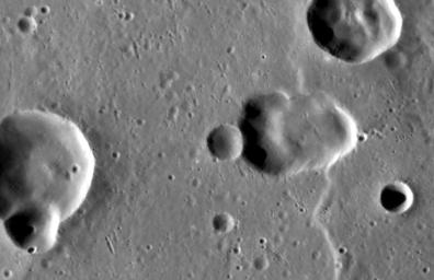
The Caloris basin contains a complex mix of impact , tectonic , and volcanic features. At center-right, the elongate depression may be a volcanic vent within the basin. This feature highlights the ambiguity that sometimes arises in discerning whether a depression is due to an impact or a volcanic event, as both can leave elongate depressions. One clue that might point to volcanism is the depression's slightly irregular shape; another is the apparent lack of a rim of impact ejecta that is raised above the baseline level of the surrounding terrain.
This image was acquired as a high-resolution targeted observation. Targeted observations are images of a small area on Mercury's surface at resolutions much higher than the 200-meter/pixel morphology base map. It is not possible to cover all of Mercury's surface at this high resolution, but typically several areas of high scientific interest are imaged in this mode each week.
Date acquired:
June 30, 2013
Image Mission Elapsed Time (MET):
14936140
Image ID:
4355811
Instrument:
Narrow Angle Camera (NAC) of the Mercury Dual Imaging System (MDIS)
Center Latitude:
24.18°
Center Longitude:
148.1° E
Resolution:
48 meters/pixel
Scale:
The proposed vent is 17.9 km (11.1 mi.) across
Incidence Angle:
66.0°
Emission Angle:
50.3°
Phase Angle:
115.4°
Background Info:
The MESSENGER spacecraft is the first ever to orbit the planet Mercury, and the spacecraft's seven scientific instruments and radio science investigation are unraveling the history and evolution of the Solar System's innermost planet. MESSENGER acquired over 150,000 images and extensive other data sets. MESSENGER is capable of continuing orbital operations until early 2015.
For information regarding the use of images, see the MESSENGER image use policy .
Cataloging Keywords:
| Name | Value | Additional Values |
|---|---|---|
| Target | Mercury | |
| System | ||
| Target Type | Planet | |
| Mission | MESSENGER | |
| Instrument Host | MESSENGER | |
| Host Type | Orbiter | |
| Instrument | Mercury Dual Imaging System (MDIS) | |
| Detector | Narrow Angle Camera (NAC) | |
| Extra Keywords | Crater, Grayscale, Impact, Map, Radio, Volcano | |
| Acquisition Date | ||
| Release Date | 2013-09-16 | |
| Date in Caption | 2013-06-30 | |
| Image Credit | NASA/Johns Hopkins University Applied Physics Laboratory/Carnegie Institution of Washington | |
| Source | photojournal.jpl.nasa.gov/catalog/PIA17497 | |
| Identifier | PIA17497 | |
