|
New Maps of Mercury!
- Click the image above for a larger view
- Full-Res JPEG (3989 x 2784) (1.9 MB)
- Full-Res TIFF (3989 x 2784) (33.3 MB)
Caption:
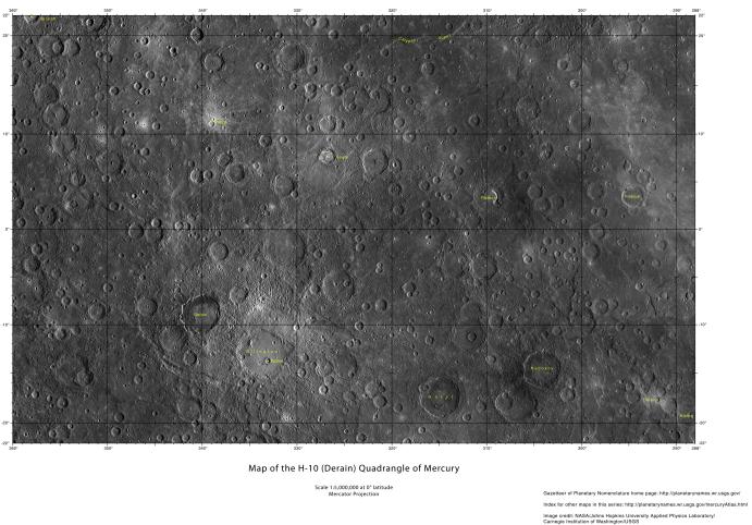
A new set of Mercury maps are available on the USGS website . These maps utilize the current best MESSENGER mosaic of Mercury , which covers 100% of the surface. Mercury's surface is divided into 15 different quadrangles. The H-10 quadrangle, which is named for the crater Derain , is shown here at half the available resolution. For the full resolution map of this region, and all of Mercury's surface, visit the USGS website .
Map Quadrangles:
H-10 Derain
Center Latitude:
0°
Center Longitude:
36° E (324° W)
Scale:
Derain has a diameter of 167 km (104 miles)
USGS Maps of Mercury website:
http://planetarynames.wr.usgs.gov/Page/mercuryQuadMap
Background Info:
The MESSENGER spacecraft is the first ever to orbit the planet Mercury, and the spacecraft's seven scientific instruments and radio science investigation are unraveling the history and evolution of the Solar System's innermost planet. MESSENGER acquired over 150,000 images and extensive other data sets. MESSENGER is capable of continuing orbital operations until early 2015.
For information regarding the use of images, see the MESSENGER image use policy .
Cataloging Keywords:
| Name | Value | Additional Values |
|---|---|---|
| Target | Mercury | |
| System | ||
| Target Type | Planet | |
| Mission | MESSENGER | |
| Instrument Host | MESSENGER | |
| Host Type | Orbiter | |
| Instrument | ||
| Detector | ||
| Extra Keywords | Color, Crater, Map, Radio | |
| Acquisition Date | ||
| Release Date | 2013-11-04 | |
| Date in Caption | ||
| Image Credit | NASA/Johns Hopkins University Applied Physics Laboratory/Carnegie Institution of Washington | |
| Source | photojournal.jpl.nasa.gov/catalog/PIA17627 | |
| Identifier | PIA17627 | |