|
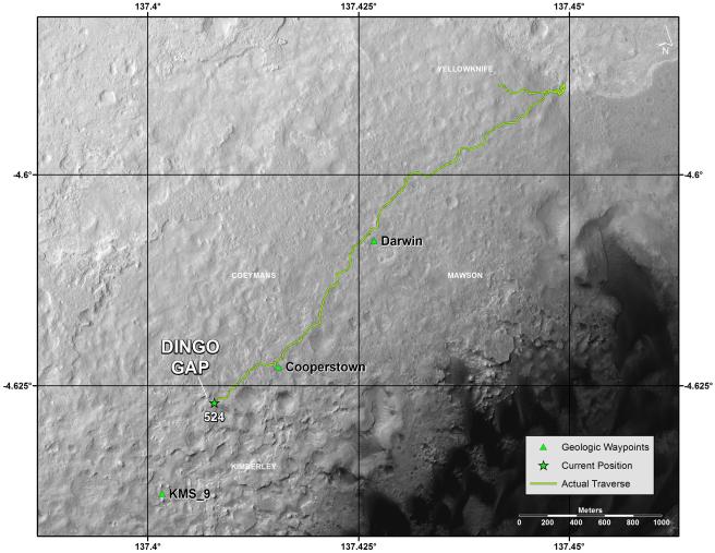
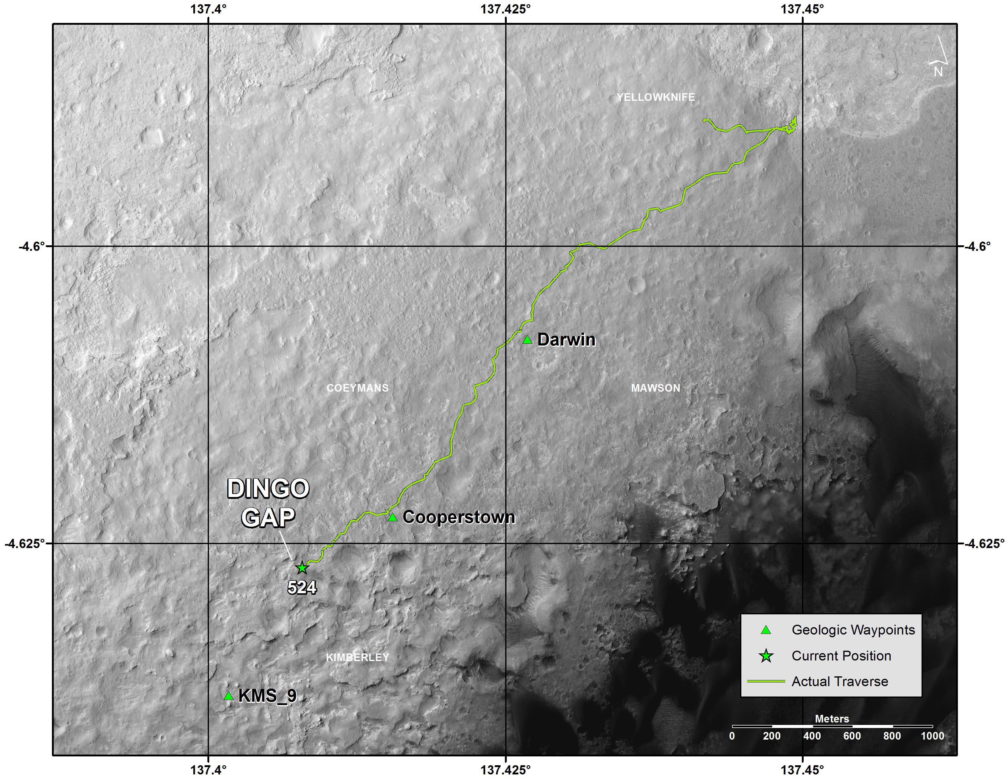
Traverse Map for Mars Rover Curiosity as of Jan. 26, 2014
- Click the image above for a larger view
- Full-Res JPEG (3300 x 2550) (1.2 MB)
- Full-Res TIFF (3300 x 2550) (25.3 MB)
Caption:
This map shows the route that NASA's Curiosity Mars rover drove inside Gale Crater from its landing in August 2013 through the 524th Martian day, or sol, of the mission (Jan. 26, 2014). The rover is approaching a gap between two low scarps, "Dingo Gap." Team members are assessing whether to use that gap, or a nearby path, to reach a possible route southwestward over smoother ground than expected over an alternative route. The assessments for choice of routes use images from the rover and also orbital images from the High Resolution Imaging Science Experiment (HiRISE) camera on NASA's Mars Reconnaissance Orbiter.
The map indicates waypoints "Darwin" and "Cooperstown," where researchers used instruments on Curiosity to examine local outcrops. Another potential waypoint candidate is "KMS-9" on the rover's way toward its long-term science destination on the lower slopes of Mount Sharp.
The base map is from the orbiting HiRISE camera. North is toward the top. The dark ground south of the rover's route has dunes of dark, wind-blown material. The 1,000-meter scale bar at lower right is about six-tenths of a mile long.
Background Info:
NASA's Jet Propulsion Laboratory, a division of the California Institute of Technology, Pasadena, manages the Mars Science Laboratory Project and Mars Reconnaissance Orbiter for NASA's Science Mission Directorate, Washington. JPL designed and built the project's Curiosity rover. The University of Arizona, Tucson, operates HiRISE, which was built by Ball Aerospace & Technologies Corp., Boulder, Colo.
More information about Curiosity is online at http://www.nasa.gov/msl and http://mars.jpl.nasa.gov/msl/ .
Cataloging Keywords:
| Name | Value | Additional Values |
|---|---|---|
| Target | Mars | |
| System | ||
| Target Type | Planet | |
| Mission | Mars Reconnaissance Orbiter (MRO) | Mars Science Laboratory (MSL) |
| Instrument Host | Mars Reconnaissance Orbiter | Curiosity Rover |
| Host Type | Orbiter | Rover |
| Instrument | High Resolution Imaging Science Experiment (HiRISE) | |
| Detector | ||
| Extra Keywords | Color, Crater, Dune, Map | |
| Acquisition Date | ||
| Release Date | 2014-01-29 | |
| Date in Caption | 2014-01-26 | |
| Image Credit | NASA/JPL-Caltech | |
| Source | photojournal.jpl.nasa.gov/catalog/PIA17765 | |
| Identifier | PIA17765 | |