|
Olivine-Bearing Dune Fields and Wall Rock in Coprates Chasma
- Click the image above for a larger view
- Full-Res JPEG (2560 x 1920) (884.9 kB)
- Full-Res TIFF (2560 x 1920) (14.8 MB)
Caption:

Map Projected Browse Image
Click on the image for larger version
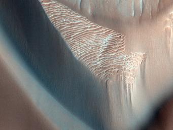
In this image, lower wall rock spurs are found that spread dark materials onto a dune field, suggesting local wall materials are a nearby sediment source for dunes. This subimage shows the interface between wall materials and dunes in the northwest portion of the main image.
Dune sand, wall spurs, and boulders are all partially composed of olivine (according to CRISM data), a common mineral formed in volcanic processes, supporting the notion for local sourcing of dunes.
Olivine is highly susceptible to weathering by aqueous processes indicating these dunes and the wall debris formed after any such activity. Interestingly, clay minerals (known as phyllosilicates) are detected farther up the wall suggesting that aqueous alteration of wall materials has occurred in the ancient past.
Background Info:
HiRISE is one of six instruments on NASA's Mars Reconnaissance Orbiter. The University of Arizona, Tucson, operates the orbiter's HiRISE camera, which was built by Ball Aerospace & Technologies Corp., Boulder, Colo. NASA's Jet Propulsion Laboratory, a division of the California Institute of Technology in Pasadena, manages the Mars Reconnaissance Orbiter Project for the NASA Science Mission Directorate, Washington.
Cataloging Keywords:
| Name | Value | Additional Values |
|---|---|---|
| Target | Mars | |
| System | ||
| Target Type | Planet | |
| Mission | Mars Reconnaissance Orbiter (MRO) | |
| Instrument Host | Mars Reconnaissance Orbiter | |
| Host Type | Orbiter | |
| Instrument | High Resolution Imaging Science Experiment (HiRISE) | Compact Reconnaissance Imaging Spectrometer for Mars (CRISM) |
| Detector | ||
| Extra Keywords | Color, Dune, Map, Volcano | |
| Acquisition Date | ||
| Release Date | 2013-05-01 | |
| Date in Caption | ||
| Image Credit | NASA/JPL-Caltech/Univ. of Arizona | |
| Source | photojournal.jpl.nasa.gov/catalog/PIA17869 | |
| Identifier | PIA17869 | |
