|
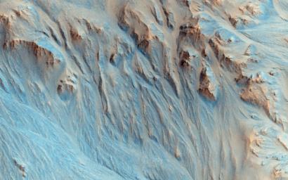
Alluvial Fans in Mojave Crater
- Click the image above for a larger view
- Full-Res JPEG (2880 x 1800) (898.5 kB)
- Full-Res TIFF (2880 x 1800) (15.6 MB)
Caption:

Map Projected Browse Image
Click on the image for larger version
Stereo data from an anaglyph (or 3D) image shows that the landscape in this observation is pervasively eroded, right up to the tops of the ridges, with channels extending down into depositional fans much like alluvial fans in the Mojave Desert.
This can be explained by something like rainfall, but this crater is geologically young, only a few hundred million years old, when Mars' atmosphere was thought to be too depleted to support rainfall. From the surrounding region we can see that only the Mojave ejecta is eroded, not adjacent landscapes. This suggests that the ejecta landed wet and itself initiated the erosion, rather than rainfall from clouds.
"Subsurface ice may have melted and mixed with the crater ejecta, which fell as a wet slurry of debris. But, that's just my favorite theory -- other geologists favor different interpretations." [Alfred McEwen]
This is a stereo pair with ESP_039695_1875 .
Background Info:
The University of Arizona, Tucson, operates HiRISE, which was built by Ball Aerospace & Technologies Corp., Boulder, Colorado. NASA's Jet Propulsion Laboratory, a division of the California Institute of Technology in Pasadena, manages the Mars Reconnaissance Orbiter Project and Mars Science Laboratory Project for NASA's Science Mission Directorate, Washington.
Cataloging Keywords:
| Name | Value | Additional Values |
|---|---|---|
| Target | Mars | |
| System | ||
| Target Type | Planet | |
| Mission | Mars Reconnaissance Orbiter (MRO) | Mars Science Laboratory (MSL) |
| Instrument Host | Mars Reconnaissance Orbiter | Curiosity Rover |
| Host Type | Orbiter | Rover |
| Instrument | High Resolution Imaging Science Experiment (HiRISE) | |
| Detector | ||
| Extra Keywords | Atmosphere, Color, Crater, Map | |
| Acquisition Date | ||
| Release Date | 2015-05-20 | |
| Date in Caption | ||
| Image Credit | NASA/JPL-Caltech/Univ. of Arizona | |
| Source | photojournal.jpl.nasa.gov/catalog/PIA18563 | |
| Identifier | PIA18563 | |
