|
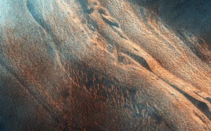
The Side of Chasma Boreale
- Click the image above for a larger view
- Full-Res JPEG (2880 x 1800) (1.2 MB)
- Full-Res TIFF (2880 x 1800) (15.6 MB)
Caption:

Map Projected Browse Image
Click on the image for larger version
Chasma Boreale is the 560-kilometer long valley that cuts through the Northern Polar layered deposits of Mars.
The section that it exposes show fine scaled layering and a major unconformity, where the azimuth of the beds changes markedly. This is is characteristic of the polar layered deposits. The formation of the unconformity suggests a time when the lower sediments were being eroded rather than deposited. The extracted image shows a roughly 4 x 4 kilometer area across the unconformity .
The polar layered deposits are weakly cemented rocks, and so lying over the scarps you can see lines of mass wasting where dust and sand size particles have slumped downhill. This image is part of a planned stereo pair, and was in the late summer in the Northern Hemisphere of Mars.
Comparing images like this to those taken in previous years and in different seasons allows a more accurate understanding of current surface processes on the Red Planet.
This is a stereo pair with ESP_036515_2650 .
Background Info:
HiRISE is one of six instruments on NASA's Mars Reconnaissance Orbiter. The University of Arizona, Tucson, operates HiRISE, which was built by Ball Aerospace & Technologies Corp., Boulder, Colorado. NASA's Jet Propulsion Laboratory, a division of the California Institute of Technology in Pasadena, manages the Mars Reconnaissance Orbiter Project for NASA's Science Mission Directorate, Washington.
Cataloging Keywords:
| Name | Value | Additional Values |
|---|---|---|
| Target | Mars | |
| System | ||
| Target Type | Planet | |
| Mission | Mars Reconnaissance Orbiter (MRO) | |
| Instrument Host | Mars Reconnaissance Orbiter | |
| Host Type | Orbiter | |
| Instrument | High Resolution Imaging Science Experiment (HiRISE) | |
| Detector | ||
| Extra Keywords | Color, Dust, Map | |
| Acquisition Date | ||
| Release Date | 2014-08-13 | |
| Date in Caption | ||
| Image Credit | NASA/JPL-Caltech/Univ. of Arizona | |
| Source | photojournal.jpl.nasa.gov/catalog/PIA18646 | |
| Identifier | PIA18646 | |
