|
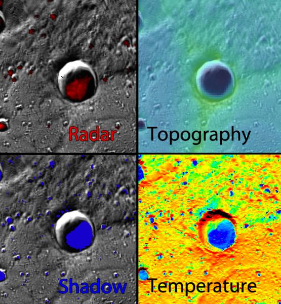
Water Ice Data Exploration (WIDE) Tool
- Click the image above for a larger view
- Full-Res JPEG (666 x 720) (120.9 kB)
- Full-Res TIFF (666 x 720) (1.4 MB)
Caption:
Want to learn more about the permanent darkness inside the crater from Monday's Featured Image? Use the Water Ice Data Exploration (WIDE) tool! The four views shown here were captured from the WIDE tool, and the evidence from the radar, topography, shadow, and temperature datasets all support the presence of water ice in this crater!
Crater Center Latitude:
83.8°
Crater Center Longitude:
31.7° E
Scale:
This crater has a diameter of 24 kilometers (15 miles)
Background Info:
The MESSENGER spacecraft is the first ever to orbit the planet Mercury, and the spacecraft's seven scientific instruments and radio science investigation are unraveling the history and evolution of the Solar System's innermost planet. During the first two years of orbital operations, MESSENGER acquired over 150,000 images and extensive other data sets. MESSENGER is capable of continuing orbital operations until early 2015.
For information regarding the use of images, see the MESSENGER image use policy .
Cataloging Keywords:
| Name | Value | Additional Values |
|---|---|---|
| Target | Mercury | |
| System | ||
| Target Type | Planet | |
| Mission | MESSENGER | |
| Instrument Host | MESSENGER | |
| Host Type | Orbiter | |
| Instrument | Mercury Dual Imaging System (MDIS) | |
| Detector | ||
| Extra Keywords | Color, Crater, Radar, Radio, Shadow, Water | |
| Acquisition Date | ||
| Release Date | 2014-11-19 | |
| Date in Caption | ||
| Image Credit | NASA/Johns Hopkins University Applied Physics Laboratory/Carnegie Institution of Washington | |
| Source | photojournal.jpl.nasa.gov/catalog/PIA18958 | |
| Identifier | PIA18958 | |