|
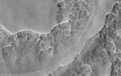
Filled Crater and Scallops
- Click the image above for a larger view
- Full-Res JPEG (2880 x 1800) (1.2 MB)
- Full-Res TIFF (2880 x 1800) (5.2 MB)
Caption:

Map Projected Browse Image
Click on the image for larger version
In this observation made for a study of ancient craters, we see the craters filled with smooth material that has subsequently degraded into scallops. These formations might be possibly due to ground ice sublimation.
High resolution can help to estimate any differences in roughness on the smoother main mantle and in the eroded hollows. With the enhanced color swath , we might be able to view composition variations of the material.
This caption is based on the original science rationale.
Background Info:
The University of Arizona, Tucson, operates HiRISE, which was built by Ball Aerospace & Technologies Corp., Boulder, Colo. NASA's Jet Propulsion Laboratory, a division of the California Institute of Technology in Pasadena, manages the Mars Reconnaissance Orbiter Project for NASA's Science Mission Directorate, Washington.
Cataloging Keywords:
| Name | Value | Additional Values |
|---|---|---|
| Target | Mars | |
| System | ||
| Target Type | Planet | |
| Mission | Mars Reconnaissance Orbiter (MRO) | |
| Instrument Host | Mars Reconnaissance Orbiter | |
| Host Type | Orbiter | |
| Instrument | High Resolution Imaging Science Experiment (HiRISE) | |
| Detector | ||
| Extra Keywords | Crater, Grayscale, Map | |
| Acquisition Date | ||
| Release Date | 2015-01-28 | |
| Date in Caption | ||
| Image Credit | NASA/JPL-Caltech/University of Arizona | |
| Source | photojournal.jpl.nasa.gov/catalog/PIA19288 | |
| Identifier | PIA19288 | |
