Yardangs in Arsinoes Chaos, Mars
Caption:

Map Projected Browse Image
Click on the image for larger version
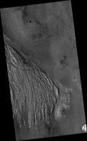
Several terrain types converge in this scene from the Arsinoes Chaos region of Mars, which is in the far eastern portion of Mars' Valles Marineris canyon system. The jumbled chaos terrain is likely related to massive water-carved outflow channels that started in this area and flowed north onto Mars' northern plains.
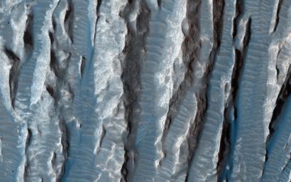
The slightly curving bright terrain is composed of yardangs. Yardangs are portions of rock that have been sandblasted into long, skinny ridges by saltating (or bouncing) sand particles blowing in the wind.
Transverse sand ridges lie between the yardangs (
zoom in
). These sand ridges are termed "transverse aeolian ridges" and are not moving in Mars' current climate. They are a mystery -- midway in height between dunes (formed from saltating sand) and ripples (formed by "splashed" sand grains).
The location is at 7 degrees south latitude, 332 degrees east latitude. The image is an excerpt from HiRISE observation ESP_039563_1730. Other image products from this observation are available at
http://hirise.lpl.arizona.edu/ESP_039563_1730
.
Background Info:
This view of Martian surface features shaped by effects of winds was captured by the High Resolution Imaging Science Experiment (HiRISE) camera on NASA's Mars Reconnaissance Orbiter on Jan. 4, 2015. The spacecraft has been orbiting Mars since March 2006. On Feb. 7, 2015, it completed its 40,000th orbit around Mars.
The University of Arizona, Tucson, operates HiRISE, which was built by Ball Aerospace & Technologies Corp., Boulder, Colo. NASA's Jet Propulsion Laboratory, a division of the California Institute of Technology in Pasadena, manages the Mars Reconnaissance Orbiter Project for NASA's Science Mission Directorate, Washington.
Cataloging Keywords:
| Name |
Value |
Additional Values |
| Target |
Mars |
|
| System |
|
|
| Target Type |
Planet |
|
| Mission |
Mars Reconnaissance Orbiter (MRO) |
Mariner |
| Instrument Host |
Mars Reconnaissance Orbiter |
|
| Host Type |
Orbiter |
Flyby Spacecraft |
| Instrument |
High Resolution Imaging Science Experiment (HiRISE) |
|
| Detector |
|
|
| Extra Keywords |
Color, Dune, Map, Water |
| Acquisition Date |
|
| Release Date |
2015-02-04 |
| Date in Caption |
|
|
| Image Credit |
NASA/JPL-Caltech/University of Arizona |
| Source |
photojournal.jpl.nasa.gov/catalog/PIA19291 |
| Identifier |
PIA19291 |

 Planetary Data System

