
|
Global Map of Pluto
- Click the image above for a larger view
- Full-Res JPEG (18630 x 9315) (5.2 MB)
- Full-Res TIFF (18630 x 9315) (173.6 MB)
Caption:
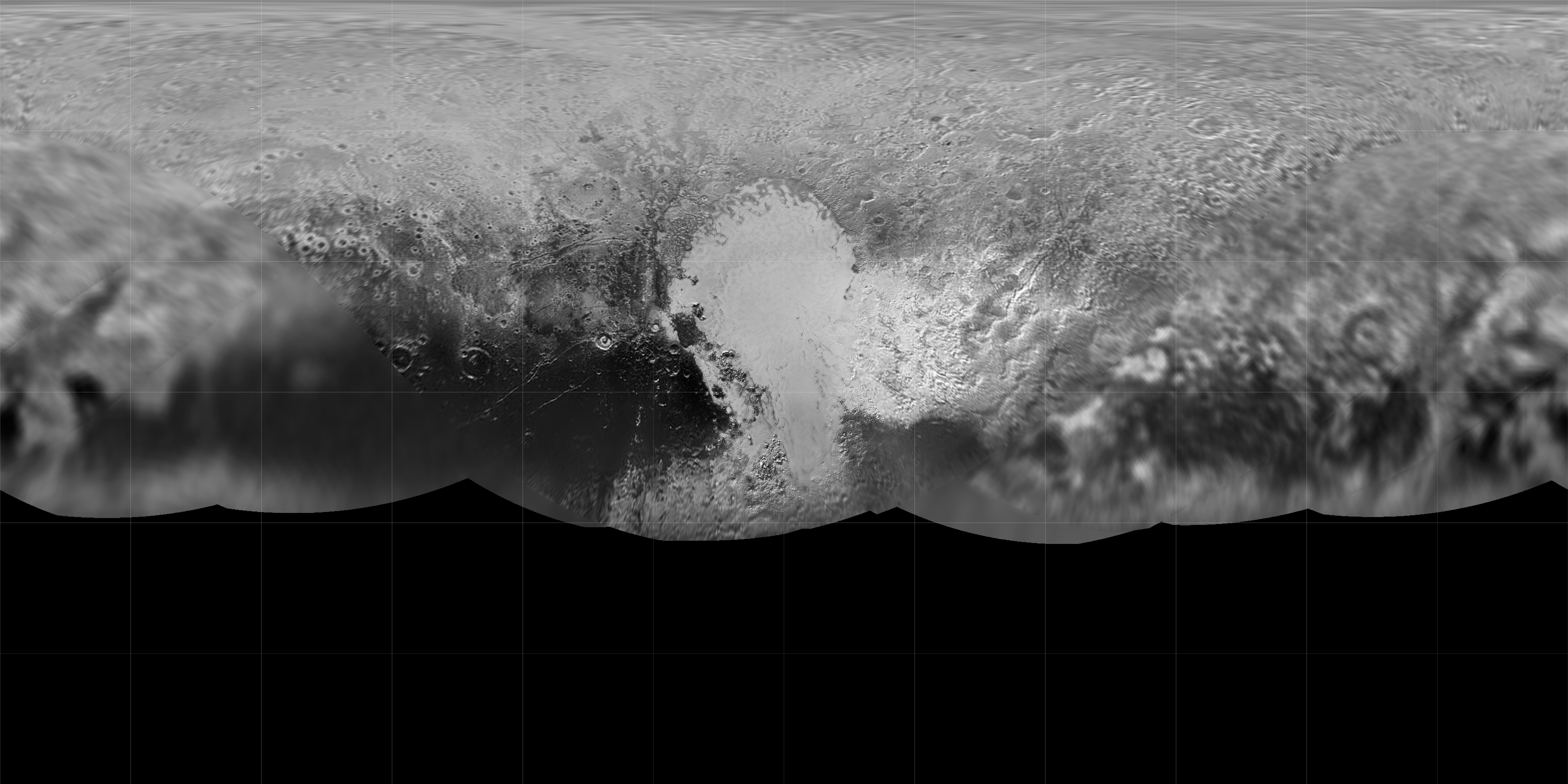
Gridded Version
Click on the image for larger version
The science team of NASA's New Horizons mission has produced an updated global map of the dwarf planet Pluto. The map includes all resolved images of the surface acquired between July 7-14, 2015, at pixel resolutions ranging from 40 kilometers (24 miles) on the Charon-facing hemisphere (left and right sides of the map) to 400 meters (1,250 feet) on the anti-Charon facing hemisphere (map center). Many additional images are expected in fall of 2015 and these will be used to complete the global map.
Background Info:
The New Horizons spacecraft flew past Pluto and its moons on July 14. The Johns Hopkins University Applied Physics Laboratory in Laurel, Maryland, designed, built, and operates the New Horizons spacecraft, and manages the mission for NASA's Science Mission Directorate. SwRI, based in San Antonio, leads the science team, payload operations and encounter science planning. New Horizons is part of the New Frontiers Program managed by NASA's Marshall Space Flight Center in Huntsville, Alabama.
Cataloging Keywords:
| Name | Value | Additional Values |
|---|---|---|
| Target | Pluto | Charon |
| System | Pluto | Kuiper Belt |
| Target Type | Satellite | Dwarf Planet, KBO |
| Mission | New Horizons | |
| Instrument Host | New Horizons | |
| Host Type | Flyby Spacecraft | |
| Instrument | Long Range Reconnaissance Imager (LORRI) | |
| Detector | ||
| Extra Keywords | Grayscale, Map | |
| Acquisition Date | ||
| Release Date | 2015-07-27 | |
| Date in Caption | ||
| Image Credit | NASA/Johns Hopkins University Applied Physics Laboratory/Southwest Research Institute | |
| Source | photojournal.jpl.nasa.gov/catalog/PIA19858 | |
| Identifier | PIA19858 | |