|
Enceladus Dalmatian Terrain Close-up
- Click the image above for a larger view
- Full-Res JPEG (1342 x 1353) (153.3 kB)
- Full-Res TIFF (1342 x 1353) (2.5 MB)
Caption:
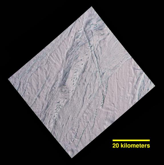
During its final close flyby of Saturn's moon Enceladus, NASA's Cassini spacecraft revisited a landscape, and a mystery, that it had originally glimpsed more than 10 years earlier.
In views of this terrain captured during a 2005 flyby (see PIA06188 ), imaging scientists noticed small dark spots of an uncertain nature. Observing the same features in this false-color view, at higher resolution than before, provides some new insights. The spots are evidently large, relatively dark protrusions of solid "bedrock" ice and ice blocks scattered on and around the prominent ridge that runs across the scene from north to south (from top center toward lower left). The ice blocks range in size from dozens to hundreds of feet (tens to hundreds of meters).
The false-color view uses an ultraviolet filter centered at 338 nanometers for blue, a green filter centered at 568 nanometers for green and a near-infrared filter centered at 930 nanometers for red -- thus covering a wider spectrum region than the human eye.
As in earlier Cassini views of Enceladus using the same combination of color filters (see PIA06254 ), green-hued features represent coarse-grained or solid ice. Exposures of these kinds of ices are also found on the walls of cracks and troughs in this scene and elsewhere on Enceladus.
To an observer on the surface, the prominent north-south trending ridge might look superficially like icy flatirons (tilted, triangular outcroppings of rock), but probably more shallowly dipping than terrestrial examples. The exposed line of ice blocks along its ridge crest might make it look a bit like a hogback (a narrow ridge with steep sides, often with vertical rocky outcrops along the top).
On Enceladus, with no wind to scour loose particulate ice or "snow" off of them, the solid blocks are probably cleared by some combination of downslope movement of particulates, and perhaps sublimation.
This image has a spatial scale of about 220 feet (67 meters) per pixel at its center, which is nearly twice the resolution of the earlier view ( PIA06188 ).
This terrain is on the moon's Saturn-facing side, a few degrees south of the equator. The view has been rotated so that north on Enceladus is up. The view was obtained by the Cassini spacecraft narrow-angle camera on Dec. 19, 2015.
Background Info:
The Cassini mission is a cooperative project of NASA, ESA (the European Space Agency) and the Italian Space Agency. The Jet Propulsion Laboratory, a division of the California Institute of Technology in Pasadena, manages the mission for NASA's Science Mission Directorate, Washington. The Cassini orbiter and its two onboard cameras were designed, developed and assembled at JPL. The imaging operations center is based at the Space Science Institute in Boulder, Colorado.
For more information about the Cassini-Huygens mission visit http://saturn.jpl.nasa.gov and http://www.nasa.gov/cassini . The Cassini imaging team homepage is at http://ciclops.org .
Cataloging Keywords:
| Name | Value | Additional Values |
|---|---|---|
| Target | Enceladus | Saturn |
| System | Saturn | |
| Target Type | Satellite | Planet |
| Mission | Cassini-Huygens | |
| Instrument Host | Cassini Orbiter | |
| Host Type | Orbiter | |
| Instrument | Imaging Science Subsystem (ISS) | |
| Detector | Narrow Angle Camera | |
| Extra Keywords | Atmosphere, Color, Infrared, Rotation, Storm, Ultraviolet, Visual | |
| Acquisition Date | ||
| Release Date | 2016-01-13 | |
| Date in Caption | 2015-12-19 | |
| Image Credit | NASA/JPL-Caltech/Space Science Institute | |
| Source | photojournal.jpl.nasa.gov/catalog/PIA20017 | |
| Identifier | PIA20017 | |