|
The Coming and Going of Ice
- Click the image above for a larger view
- Full-Res JPEG (2880 x 1800) (898.6 kB)
- Full-Res TIFF (2880 x 1800) (15.6 MB)
Caption:

Map Projected Browse Image
Click on the image for larger version
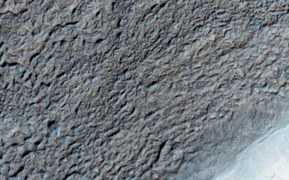
Like Earth's water table, Mars has an ice table. Sometimes, the ice table coincides with the ground's surface as it does here. The knobby, pitted terrain is caused when ice is deposited and then sublimates over and over again. This geologic process is called "accrescence" and "decrescence" and also occurs on Neptune's moon Triton and on Pluto, though in the outer Solar System the ice is not water ice.
Other evidence for ice here includes the rope-like, curved flow feature that resembles glacial flow.
Solis Planum -- a huge mound south of Valles Marineris -- is the location of this image.
Background Info:
The University of Arizona, Tucson, operates HiRISE, which was built by Ball Aerospace & Technologies Corp., Boulder, Colo. NASA's Jet Propulsion Laboratory, a division of the California Institute of Technology in Pasadena, manages the Mars Reconnaissance Orbiter Project for NASA's Science Mission Directorate, Washington.
Cataloging Keywords:
| Name | Value | Additional Values |
|---|---|---|
| Target | Mars | |
| System | ||
| Target Type | Planet | |
| Mission | Mars Reconnaissance Orbiter (MRO) | Mariner |
| Instrument Host | Mars Reconnaissance Orbiter | |
| Host Type | Orbiter | Flyby Spacecraft |
| Instrument | High Resolution Imaging Science Experiment (HiRISE) | |
| Detector | ||
| Extra Keywords | Color, Map, Water | |
| Acquisition Date | ||
| Release Date | 2015-12-10 | |
| Date in Caption | ||
| Image Credit | NASA/JPL-Caltech/Univ. of Arizona | |
| Source | photojournal.jpl.nasa.gov/catalog/PIA20208 | |
| Identifier | PIA20208 | |
