|
Dawn LAMO Image 27
- Click the image above for a larger view
- Full-Res JPEG (1024 x 1024) (194.1 kB)
- Full-Res TIFF (1024 x 1024) (1.1 MB)
Caption:
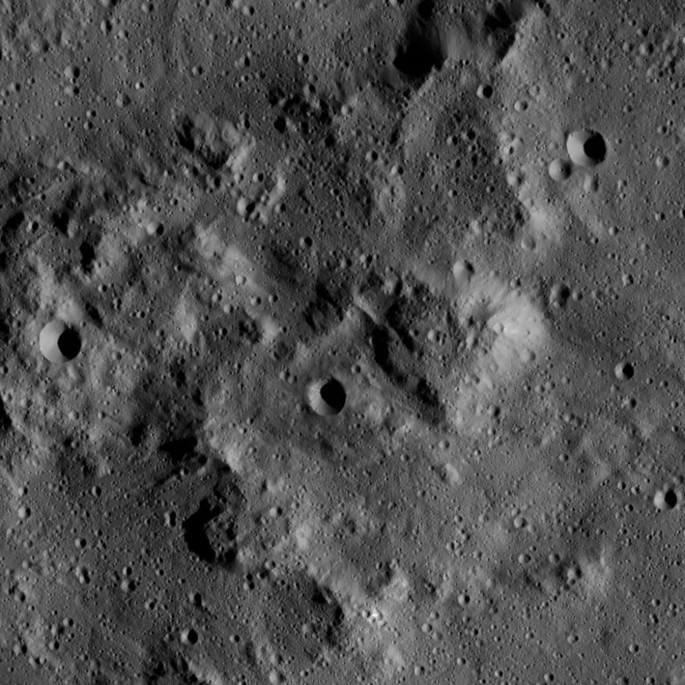
This image, taken by NASA's Dawn spacecraft, shows a knobby surface on Ceres. The region is adjacent to the giant impact crater Urvara.
Mountain-like structures with steep, smooth slopes are evident here. The smooth flanks of these hills resemble the structure of Ahuna Mons -- a prominent mountain-like structure on Ceres (see PIA20130 ).
Small crater chains are present in the lower right of the image.
The image is centered at approximately 41.1 degrees south latitude, 267.6 degrees east longitude. Dawn captured the scene on Jan. 7, 2016, from its low-altitude mapping orbit (LAMO), at an altitude of 232 miles (374 kilometers) above Ceres. The image resolution is 112 feet (34 meters) per pixel.
Background Info:
Dawn's mission is managed by JPL for NASA's Science Mission Directorate in Washington. Dawn is a project of the directorate's Discovery Program, managed by NASA's Marshall Space Flight Center in Huntsville, Alabama. UCLA is responsible for overall Dawn mission science. Orbital ATK, Inc., in Dulles, Virginia, designed and built the spacecraft. The German Aerospace Center, the Max Planck Institute for Solar System Research, the Italian Space Agency and the Italian National Astrophysical Institute are international partners on the mission team. For a complete list of acknowledgments, see http://dawn.jpl.nasa.gov/mission .
For more information about the Dawn mission, visit http://dawn.jpl.nasa.gov .
Cataloging Keywords:
| Name | Value | Additional Values |
|---|---|---|
| Target | 1 Ceres | |
| System | Main Belt | |
| Target Type | Dwarf Planet | Asteroid |
| Mission | Dawn | |
| Instrument Host | Dawn | |
| Host Type | Orbiter | |
| Instrument | Framing Camera (FC) | |
| Detector | ||
| Extra Keywords | Crater, Grayscale, Impact, Mountain | |
| Acquisition Date | ||
| Release Date | 2016-02-16 | |
| Date in Caption | 2016-01-07 | |
| Image Credit | NASA/JPL-Caltech/UCLA/MPS/DLR/IDA | |
| Source | photojournal.jpl.nasa.gov/catalog/PIA20381 | |
| Identifier | PIA20381 | |