|
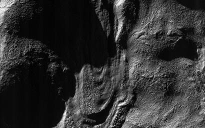
Dramatic Shadows over a Fossil Glacier
- Click the image above for a larger view
- Full-Res JPEG (2880 x 1800) (993.7 kB)
- Full-Res TIFF (2880 x 1800) (5.0 MB)
Caption:

Map Projected Browse Image
Click on the image for larger version
This image was acquired near the Martian winter solstice, when the sun was low over the horizon at this location.
The resulting illumination produces dramatic accentuation of subtle topography. The image is centered on a fossil glacial flow, no longer active. On Earth, glaciers usually melt, but on frigid Mars they may be preserved for millions of years after ceasing activity. It formed on the south-facing slope of an impact crater in the southern middle latitudes.
Background Info:
The University of Arizona, Tucson, operates HiRISE, which was built by Ball Aerospace & Technologies Corp., Boulder, Colo. NASA's Jet Propulsion Laboratory, a division of the California Institute of Technology in Pasadena, manages the Mars Reconnaissance Orbiter Project for NASA's Science Mission Directorate, Washington.
Cataloging Keywords:
| Name | Value | Additional Values |
|---|---|---|
| Target | Mars | |
| System | ||
| Target Type | Planet | |
| Mission | Mars Reconnaissance Orbiter (MRO) | |
| Instrument Host | Mars Reconnaissance Orbiter | |
| Host Type | Orbiter | |
| Instrument | High Resolution Imaging Science Experiment (HiRISE) | |
| Detector | ||
| Extra Keywords | Crater, Grayscale, Impact, Map, Shadow | |
| Acquisition Date | ||
| Release Date | 2016-02-24 | |
| Date in Caption | ||
| Image Credit | NASA/JPL-Caltech/Univ. of Arizona | |
| Source | photojournal.jpl.nasa.gov/catalog/PIA20470 | |
| Identifier | PIA20470 | |
