|
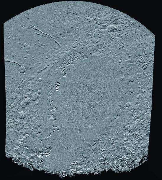
Elevation Map of Pluto’s Sunken ‘Heart’
- Click the image above for a larger view
- Full-Res JPEG (1403 x 1555) (397.9 kB)
- Full-Res TIFF (1403 x 1555) (4.9 MB)
Caption:
This shaded relief view of the region surrounding the left side of Pluto's heart-shaped feature -- informally named Sputnik Planum -- shows that the vast expanse of the icy surface is on average 2 miles (3 kilometers) lower than the surrounding terrain. Angular blocks of water ice along the western edge of Sputnik Planum can be seen "floating" in the bright deposits of softer, denser solid nitrogen.
Topographic maps of Pluto are produced from digital analysis of New Horizons stereo images acquired during the July 14, 2015 flyby. Such maps are derived from digital stereo-image mapping tools that measure the parallax -- or the difference in the apparent relative positions -- of individual features on the surface obtained at different times. Parallax displacements of high and low features are then used to directly estimate feature heights.
These topographic maps are works in progress and artifacts are still present in the current version. The map is artificially illuminated from the south, rather than the generally northern solar lighting of landscape during the time of the flyby. One of the many advantages of digital terrain maps is that they can be illuminated from any direction to best bring out different features. North is up and the total relief in the scene is approximately 4 miles (6 kilometers) from the lowest to the highest features.
Background Info:
The Johns Hopkins University Applied Physics Laboratory in Laurel, Maryland, designed, built, and operates the New Horizons spacecraft, and manages the mission for NASA's Science Mission Directorate. The Southwest Research Institute, based in San Antonio, leads the science team, payload operations and encounter science planning. New Horizons is part of the New Frontiers Program managed by NASA's Marshall Space Flight Center in Huntsville, Alabama.
Cataloging Keywords:
| Name | Value | Additional Values |
|---|---|---|
| Target | Pluto | |
| System | Pluto | Kuiper Belt |
| Target Type | Dwarf Planet | KBO |
| Mission | New Horizons | |
| Instrument Host | New Horizons | |
| Host Type | Flyby Spacecraft | |
| Instrument | Long Range Reconnaissance Imager (LORRI) | |
| Detector | ||
| Extra Keywords | Color, Map, Water | |
| Acquisition Date | ||
| Release Date | 2016-05-02 | |
| Date in Caption | 2015-07-14 | |
| Image Credit | NASA/Johns Hopkins University Applied Physics Laboratory/Southwest Research Institute | |
| Source | photojournal.jpl.nasa.gov/catalog/PIA20657 | |
| Identifier | PIA20657 | |