|
Curiosity’s Bagnold Dunes Campaign: Two Types of Dunes
- Click the image above for a larger view
- Full-Res JPEG (825 x 1118) (200.6 kB)
- Full-Res TIFF (825 x 1118) (1.5 MB)
Caption:
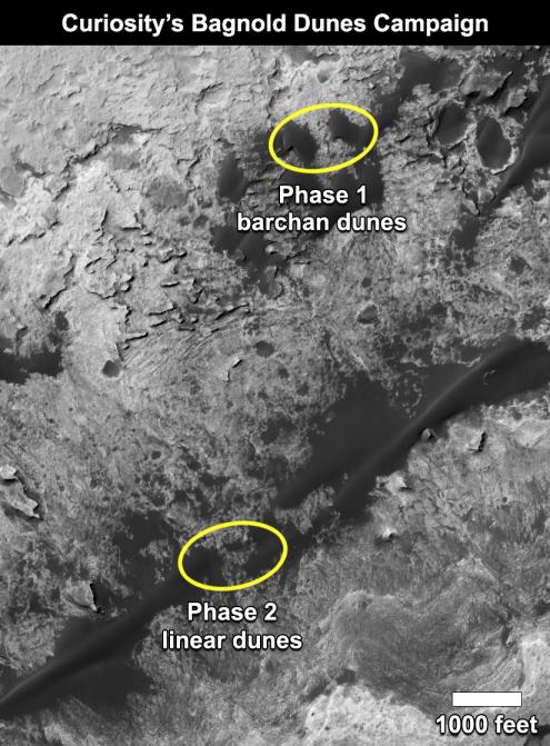
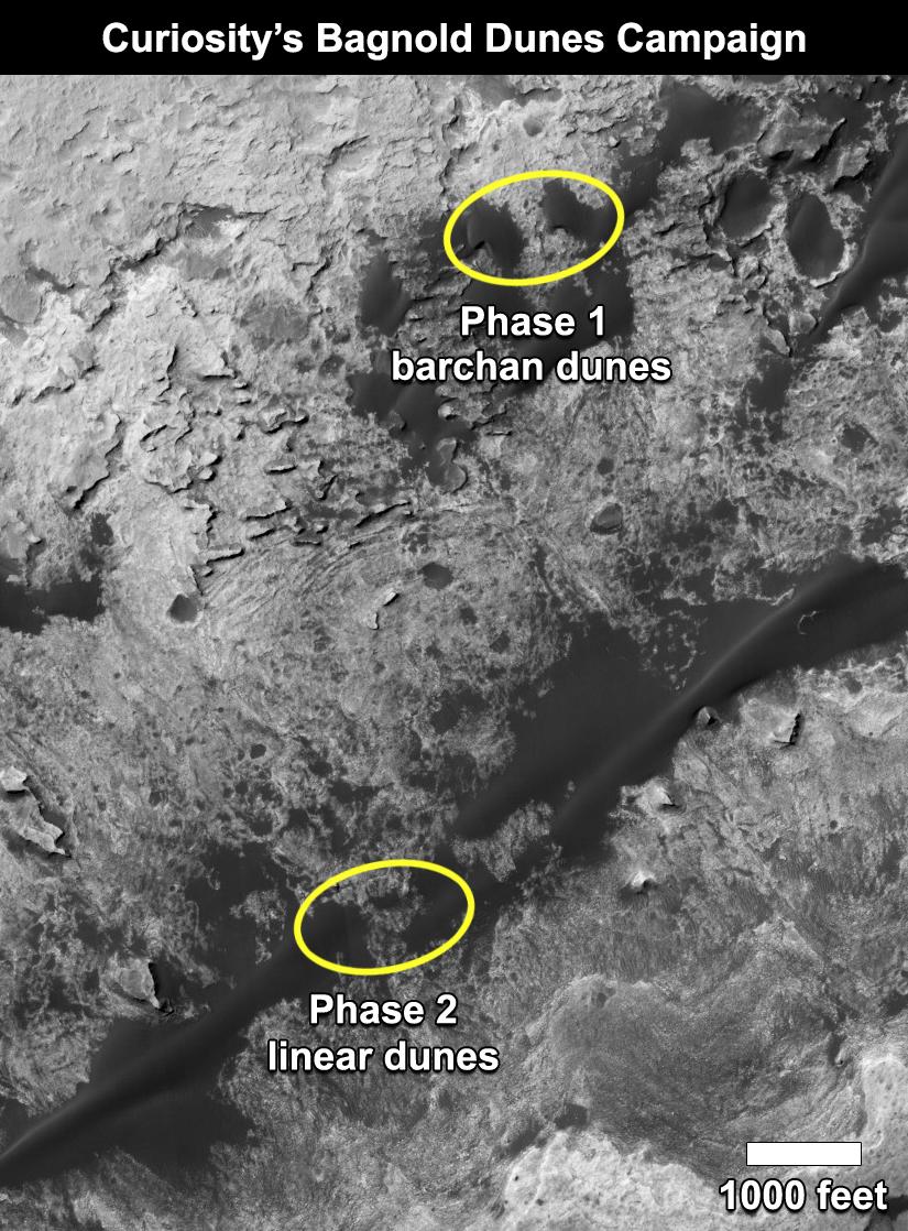
This map shows the two locations of a research campaign by NASA's Curiosity Mars rover mission to investigate active sand dunes inside Gale Crater on Mars.
The Bagnold Dunes form a dark band on the northwestern flank of Mount Sharp, inside the crater. In late 2015 and early 2016, Curiosity examined crescent-shaped dunes, called barchans, which are convex on the downwind (leeward) side. This was the first close-up study of active sand dunes anywhere other than Earth. In February 2017, the rover reached a location where the dunes are linear in shape, and the mission began Phase 2 of its dunes campaign.
A map showing Curiosity's full traverse from landing to this part of Mount Sharp is at PIA21144 , with the Phase 1 location of the dune campaign identified as "Gobabeb," a specific site where the rover scooped up sand for analysis.
The base image for the map is a portion of observation ESP_035917_1755 by the High Resolution Imaging Science Experiment (HiRISE) camera on NASA's Mars Reconnaissance Orbiter. North is up.
Background Info:
NASA's Jet Propulsion Laboratory, a division of Caltech in Pasadena, California, manages the Mars Science Laboratory Project and Mars Reconnaissance Orbiter Project for NASA's Science Mission Directorate, Washington.
For more information about Curiosity, visit http://www.nasa.gov/msl and http://mars.jpl.nasa.gov/msl .
Cataloging Keywords:
| Name | Value | Additional Values |
|---|---|---|
| Target | Mars | |
| System | ||
| Target Type | Planet | |
| Mission | Mars Reconnaissance Orbiter (MRO) | Mars Science Laboratory (MSL) |
| Instrument Host | Mars Reconnaissance Orbiter | Curiosity Rover |
| Host Type | Orbiter | Rover |
| Instrument | High Resolution Imaging Science Experiment (HiRISE) | |
| Detector | ||
| Extra Keywords | Color, Crater, Dune, Map | |
| Acquisition Date | ||
| Release Date | 2017-02-27 | |
| Date in Caption | ||
| Image Credit | NASA/JPL-Caltech/Univ. of Arizona | |
| Source | photojournal.jpl.nasa.gov/catalog/PIA21269 | |
| Identifier | PIA21269 | |