|
A Geologic Model for Eridania Basin on Ancient Mars
- Click the image above for a larger view
- Full-Res JPEG (788 x 416) (76.7 kB)
- Full-Res TIFF (788 x 416) (694.9 kB)
Caption:
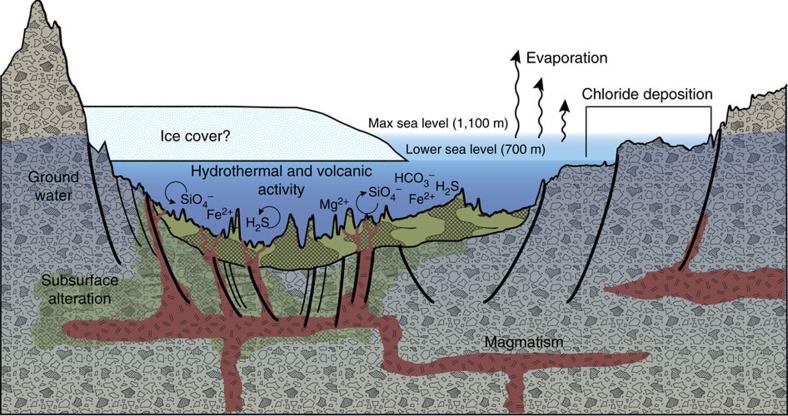
This diagram illustrates an interpretation for the origin of some deposits in the Eridania basin of southern Mars as resulting from seafloor hydrothermal activity more than 3 billion years ago.
The ground level depicted is an exaggerated topography of a transect about 280 miles (450 kilometers) long. Blue portions of the diagram depict water-depth estimates and the possibility of ice covering the ancient sea.
Thick, clay-rich deposits (green) formed through hydrothermal alteration of volcanic materials in deep water, by this model. Notations indicate deep-water reactions of iron and magnesium ions with silicates, sulfides and carbonates. Deep-seated structural discontinuities could have facilitated the ascent of magma from a mantle source. Chloride deposits formed from evaporation of seawater at higher elevations in the basin.
This graphic was included in a 2017 report " Ancient hydrothermal seafloor deposits in Eridania basin on Mars " in Nature Communications .
Cataloging Keywords:
| Name | Value | Additional Values |
|---|---|---|
| Target | Mars | |
| System | ||
| Target Type | Planet | |
| Mission | Mars Reconnaissance Orbiter (MRO) | |
| Instrument Host | Mars Reconnaissance Orbiter | |
| Host Type | Orbiter | |
| Instrument | ||
| Detector | ||
| Extra Keywords | Color, Thermal, Volcano, Water | |
| Acquisition Date | ||
| Release Date | 2017-10-06 | |
| Date in Caption | ||
| Image Credit | NASA | |
| Source | photojournal.jpl.nasa.gov/catalog/PIA22060 | |
| Identifier | PIA22060 | |