|
Locator Map for Features in Curiosity Panorama
- Click the image above for a larger view
- Full-Res JPEG (2550 x 3300) (916.2 kB)
- Full-Res TIFF (2550 x 3300) (11.7 MB)
Caption:
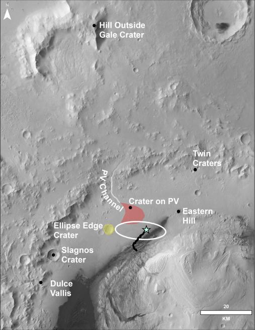
This image of the northwestern portion of Mars' Gale Crater and terrain north of it, from the European Space Agency's Mars Express orbiter, provides a locator map for some features visible in an October 2017 panorama from NASA's Curiosity Mars rover ( PIA22210 , Fig. 1).
A blue star marks the rover's landing site, on the floor of Gale Crater near the base of Mount Sharp. That layered mountain occupies the middle of the crater. The black line indicates the path of the rover's traverse from its August 2012 landing to about the location on lower Mount Sharp, where the panorama was acquired.
North is toward the top. At lower right is a 20-kilometer (12.4-mile) scale bar. The base-map image was taken by the High Resolution Stereo Camera on Mars Express.
Background Info:
NASA's Jet Propulsion Laboratory, a division of the California Institute of Technology, Pasadena, manages the Mars Science Laboratory Project for NASA's Science Mission Directorate, Washington. JPL designed and built the project's Curiosity rover and the rover's Hazcams.
More information about Curiosity is online at http://www.nasa.gov/msl and http://mars.jpl.nasa.gov/msl/ .
Cataloging Keywords:
| Name | Value | Additional Values |
|---|---|---|
| Target | Mars | |
| System | ||
| Target Type | Planet | |
| Mission | Mars Science Laboratory (MSL) | Mars Express, Mars Express (MEX) |
| Instrument Host | Curiosity Rover | Mars Express Orbiter |
| Host Type | Rover | Orbiter |
| Instrument | ||
| Detector | ||
| Extra Keywords | Color, Crater, Map, Mountain | |
| Acquisition Date | ||
| Release Date | 2018-01-30 | |
| Date in Caption | ||
| Image Credit | ESA/DLR/FU Berlin/NASA/JPL-Caltech | |
| Source | photojournal.jpl.nasa.gov/catalog/PIA22208 | |
| Identifier | PIA22208 | |