|
Gullies and Voids
- Click the image above for a larger view
- Full-Res JPEG (2880 x 1800) (1.1 MB)
- Full-Res TIFF (2880 x 1800) (15.6 MB)
Caption:

Map Projected Browse Image
Click on the image for larger version
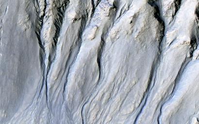
Intricate gullies have formed on the northern wall of this impact crater located in the Terra Cimmeria region in this image from NASA's Mars Reconnaissance Orbiter (MRO).
This crater may have formed in a region rich in ground water. This ground water likely flowed down the wall, eventually eroding numerous gullies while carrying sediments to form fan deposits. Ultimately the water likely infiltrated and froze beneath the surface. Other hypotheses say gullies form through carbon dioxide frost avalanches that we can see today.
What about this chain of pits snaking their way downhill ? After material was transported, subsurface voids may have formed, removing support for the overlying material. The collapse of the surface into the cavities below likely resulted in the pits and troughs, perhaps beginning a new cycle of gully formation.
The map is projected here at a scale of 50 centimeters (19.7 inches) per pixel. [The original image scale is 51 centimeters (20.1 inches) per pixel (with 2 x 2 binning); objects on the order of 153 centimeters (60.2 inches) across are resolved.] North is up.
Background Info:
The University of Arizona, Tucson, operates HiRISE, which was built by Ball Aerospace & Technologies Corp., Boulder, Colorado. NASA's Jet Propulsion Laboratory, a division of Caltech in Pasadena, California, manages the Mars Reconnaissance Orbiter Project for NASA's Science Mission Directorate, Washington.
Cataloging Keywords:
| Name | Value | Additional Values |
|---|---|---|
| Target | Mars | |
| System | ||
| Target Type | Planet | |
| Mission | Mars Reconnaissance Orbiter (MRO) | |
| Instrument Host | Mars Reconnaissance Orbiter | |
| Host Type | Orbiter | |
| Instrument | High Resolution Imaging Science Experiment (HiRISE) | |
| Detector | ||
| Extra Keywords | Color, Crater, Impact, Map, Water | |
| Acquisition Date | ||
| Release Date | 2018-02-05 | |
| Date in Caption | ||
| Image Credit | NASA/JPL-Caltech/Univ. of Arizona | |
| Source | photojournal.jpl.nasa.gov/catalog/PIA22239 | |
| Identifier | PIA22239 | |
