
|
Investigating Mars: Olympia Undae
- Click the image above for a larger view
- Full-Res JPEG (586 x 6556) (486.0 kB)
- Full-Res TIFF (586 x 6556) (3.7 MB)
Caption:
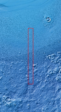
Context image
This VIS image of Olympia Undae was collected early in north polar spring. The crests of the dunes are light colored, indicative of a frost covering. As the season changes into summertime, the dune crests will lose the frost and reveal the darker sand beneath. The linear nature of transverse dunes can be seen at the bottom of the image. The density of dunes and the alignments of the dune crests varies with location, controlled by the amount of available sand and the predominant winds over time.
Olympia Undae is a vast dune field in the north polar region of Mars. It consists of a broad sand sea or erg that partly rings the north polar cap from about 120 to 240 E longitude and 78 to 83 N latitude. The dune field covers an area of approximately 470,000 km2 (bigger than California, smaller than Texas). Olympia Undae is the largest continuous dune field on Mars. Olympia Undae is not the only dune field near the north polar cap, several other smaller fields exist in the same latitude, but in other ranges of longitude, e.g. Abolos and Siton Undae. Barchan and transverse dune forms are the most common. In regions with limited available sand individual barchan dunes will form, the surface beneath and between the dunes is visible. In regions with large sand supplies, the sand sheet covers the underlying surface, and dune forms are found modifying the surface of the sand sheet. In this case transverse dunes are more common. Barchan dunes "point" down wind, transverse dunes are more linear and form parallel to the wind direction. The "square" shaped transverse dunes in Olympia Undae are due to two prevailing wind directions.
Orbit Number: 10380 Latitude: 79.7273 Longitude: 176.363 Instrument: VIS Captured: 2004-04-17 02:00
Background Info:
The Odyssey spacecraft has spent over 15 years in orbit around Mars, circling the planet more than 71,000 times. It holds the record for longest working spacecraft at Mars. THEMIS, the IR/VIS camera system, has collected data for the entire mission and provides images covering all seasons and lighting conditions. Over the years many features of interest have received repeated imaging, building up a suite of images covering the entire feature. From the deepest chasma to the tallest volcano, individual dunes inside craters and dune fields that encircle the north pole, channels carved by water and lava, and a variety of other feature, THEMIS has imaged them all. For the next several months the image of the day will focus on the Tharsis volcanoes, the various chasmata of Valles Marineris, and the major dunes fields. We hope you enjoy these images!
Please see the THEMIS Data Citation Note for details on crediting THEMIS images.
NASA's Jet Propulsion Laboratory manages the 2001 Mars Odyssey mission for NASA's Science Mission Directorate, Washington, D.C. The Thermal Emission Imaging System (THEMIS) was developed by Arizona State University, Tempe, in collaboration with Raytheon Santa Barbara Remote Sensing. The THEMIS investigation is led by Dr. Philip Christensen at Arizona State University. Lockheed Martin Astronautics, Denver, is the prime contractor for the Odyssey project, and developed and built the orbiter. Mission operations are conducted jointly from Lockheed Martin and from JPL, a division of the California Institute of Technology in Pasadena.
Cataloging Keywords:
| Name | Value | Additional Values |
|---|---|---|
| Target | Mars | |
| System | ||
| Target Type | Planet | |
| Mission | 2001 Mars Odyssey | Mariner |
| Instrument Host | Mars Odyssey | |
| Host Type | Orbiter | Flyby Spacecraft |
| Instrument | Thermal Emission Imaging System (THEMIS) | |
| Detector | ||
| Extra Keywords | Crater, Dune, Grayscale, Infrared, Thermal, Volcano, Water | |
| Acquisition Date | ||
| Release Date | 2018-03-07 | |
| Date in Caption | 2004-04-17 | |
| Image Credit | NASA/JPL-Caltech/ASU | |
| Source | photojournal.jpl.nasa.gov/catalog/PIA22290 | |
| Identifier | PIA22290 | |