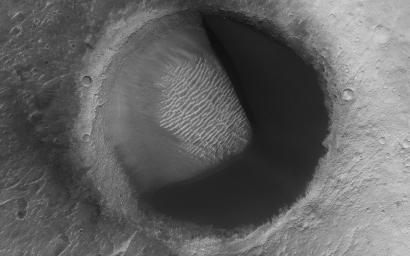
Barchan Pac-Man
Caption:

Map Projected Browse Image
Click on image for larger version
The map is projected here at a scale of 50 centimeters (19.7 inches) per pixel.
[The original image scale is 55.9 centimeters (22.0 inches) per pixel (with 2 x 2 binning); objects on the order of 168 centimeters (66.1 inches) across are resolved.] North is up.
|
|
This image from NASA's Mars Reconnaissance Orbiter shows barchan sand dunes, common on Mars and often forming vast dune fields within very large (tens to hundreds of kilometers) impact basins. The regions upwind of barchans are usually devoid of sandy bedforms, so if you were walking in a downwind direction, then the barchans would seem to appear out of nowhere.
As you walk downwind, you would notice the barchans link up ("joining arms") and eventually slope into featureless sand sheets. We call this progression of dunes a "Herschel-type dune field" named after the first place this sequence was described: Herschel Crater.
But here is something interesting: a barchan dune filling the upwind portion of a small impact crater in a
Pac-Man-like shape
. This "dune-in-a-crater" is nearly at the highest extent of the field. It is also probably a rare configuration, and over the next few tens of thousands of years the sand will be blown out of the crater.
Background Info:
The University of Arizona, Tucson, operates HiRISE, which was built by Ball Aerospace & Technologies Corp., Boulder, Colorado. NASA's Jet Propulsion Laboratory, a division of Caltech in Pasadena, California, manages the Mars Reconnaissance Orbiter Project for NASA's Science Mission Directorate, Washington.
Cataloging Keywords:
| Name |
Value |
Additional Values |
| Target |
Mars |
|
| System |
|
|
| Target Type |
Planet |
|
| Mission |
Mars Reconnaissance Orbiter (MRO) |
|
| Instrument Host |
Mars Reconnaissance Orbiter |
|
| Host Type |
Orbiter |
|
| Instrument |
High Resolution Imaging Science Experiment (HiRISE) |
|
| Detector |
|
|
| Extra Keywords |
Crater, Dune, Grayscale, Impact, Map |
| Acquisition Date |
|
| Release Date |
2018-05-14 |
| Date in Caption |
|
|
| Image Credit |
NASA/JPL-Caltech/Univ. of Arizona |
| Source |
photojournal.jpl.nasa.gov/catalog/PIA22456 |
| Identifier |
PIA22456 |

 Planetary Data System

