|
Ice Block Avalanche
- Click the image above for a larger view
- Full-Res JPEG (2880 x 1800) (1.1 MB)
- Full-Res TIFF (2880 x 1800) (15.6 MB)
Caption:
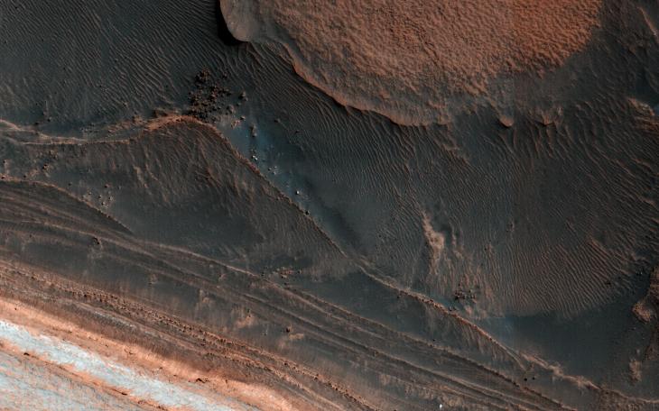
Map Projected Browse Image
Click on image for larger version
One of the most actively changing areas on Mars are the steep edges of the North Polar layered deposits. This image from NASA's Mars Reconnaissance Orbiter (MRO) shows many new ice blocks compared to an earlier image in December 2006. An animation shows one example, where a section of ice cliff collapsed. The older image (acquired in bin-2 mode) is not as sharp as the newer one.
HiRISE has been re-imaging regions first photographed in 2006 through 2007, six Mars years ago. This long baseline allows us to see large, rare changes as well as many smaller changes.
The map is projected here at a scale of 25 centimeters (9.8 inches) per pixel. [The original image scale is 31.9 centimeters (12.6 inches) per pixel (with 1 x 1 binning); objects on the order of 96 centimeters (37.8 inches) across are resolved.] North is up.
Background Info:
The University of Arizona, Tucson, operates HiRISE, which was built by Ball Aerospace & Technologies Corp., Boulder, Colorado. NASA's Jet Propulsion Laboratory, a division of Caltech in Pasadena, California, manages the Mars Reconnaissance Orbiter Project for NASA's Science Mission Directorate, Washington.
Cataloging Keywords:
| Name | Value | Additional Values |
|---|---|---|
| Target | Mars | |
| System | ||
| Target Type | Planet | |
| Mission | Mars Reconnaissance Orbiter (MRO) | |
| Instrument Host | Mars Reconnaissance Orbiter | |
| Host Type | Orbiter | |
| Instrument | High Resolution Imaging Science Experiment (HiRISE) | |
| Detector | ||
| Extra Keywords | Color, Map | |
| Acquisition Date | ||
| Release Date | 2018-06-25 | |
| Date in Caption | ||
| Image Credit | NASA/JPL-Caltech/Univ. of Arizona | |
| Source | photojournal.jpl.nasa.gov/catalog/PIA22535 | |
| Identifier | PIA22535 | |