|
Seeing through the Dusty Air
- Click the image above for a larger view
- Full-Res JPEG (2880 x 1800) (2.0 MB)
- Full-Res TIFF (2880 x 1800) (5.2 MB)
Caption:
Map Projected Browse Image
Click on image for larger version
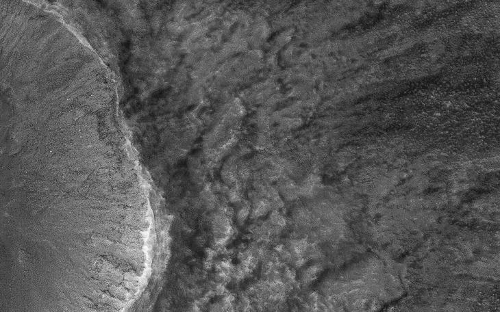
This image was acquired on July 22, 2018 by NASA's Mars Reconnaissance Orbiter. Mars has recently been enveloped in dusty haze, but the sensitivity of HiRISE enabled imaging of surface features through a moderate level of haze.
This image shows a fresh impact crater in the northern middle latitudes. A technique called "pixel binning" was needed to improve the signal, but it is still the highest-resolution image ever acquired at this location.
Pixel binning combines information of adjacent detectors in a CCD camera sensor to create one single pixel in the recorded image.
The map is projected here at a scale of 50 centimeters (19.7 inches) per pixel. [The original image scale is 60.3 centimeters (23.7 inches) per pixel (with 2 x 2 binning); objects on the order of 181 centimeters (71.3 inches) across are resolved.] North is up.
Background Info:
The University of Arizona, Tucson, operates HiRISE, which was built by Ball Aerospace & Technologies Corp., Boulder, Colorado. NASA's Jet Propulsion Laboratory, a division of Caltech in Pasadena, California, manages the Mars Reconnaissance Orbiter Project for NASA's Science Mission Directorate, Washington.
Cataloging Keywords:
| Name | Value | Additional Values |
|---|---|---|
| Target | Mars | |
| System | ||
| Target Type | Planet | |
| Mission | Mars Reconnaissance Orbiter (MRO) | |
| Instrument Host | Mars Reconnaissance Orbiter | |
| Host Type | Orbiter | |
| Instrument | High Resolution Imaging Science Experiment (HiRISE) | |
| Detector | ||
| Extra Keywords | Atmosphere, Color, Crater, Dust, Haze, Impact, Map | |
| Acquisition Date | ||
| Release Date | 2018-09-24 | |
| Date in Caption | 2018-07-22 | |
| Image Credit | NASA/JPL-Caltech/Univ. of Arizona | |
| Source | photojournal.jpl.nasa.gov/catalog/PIA22726 | |
| Identifier | PIA22726 | |