|
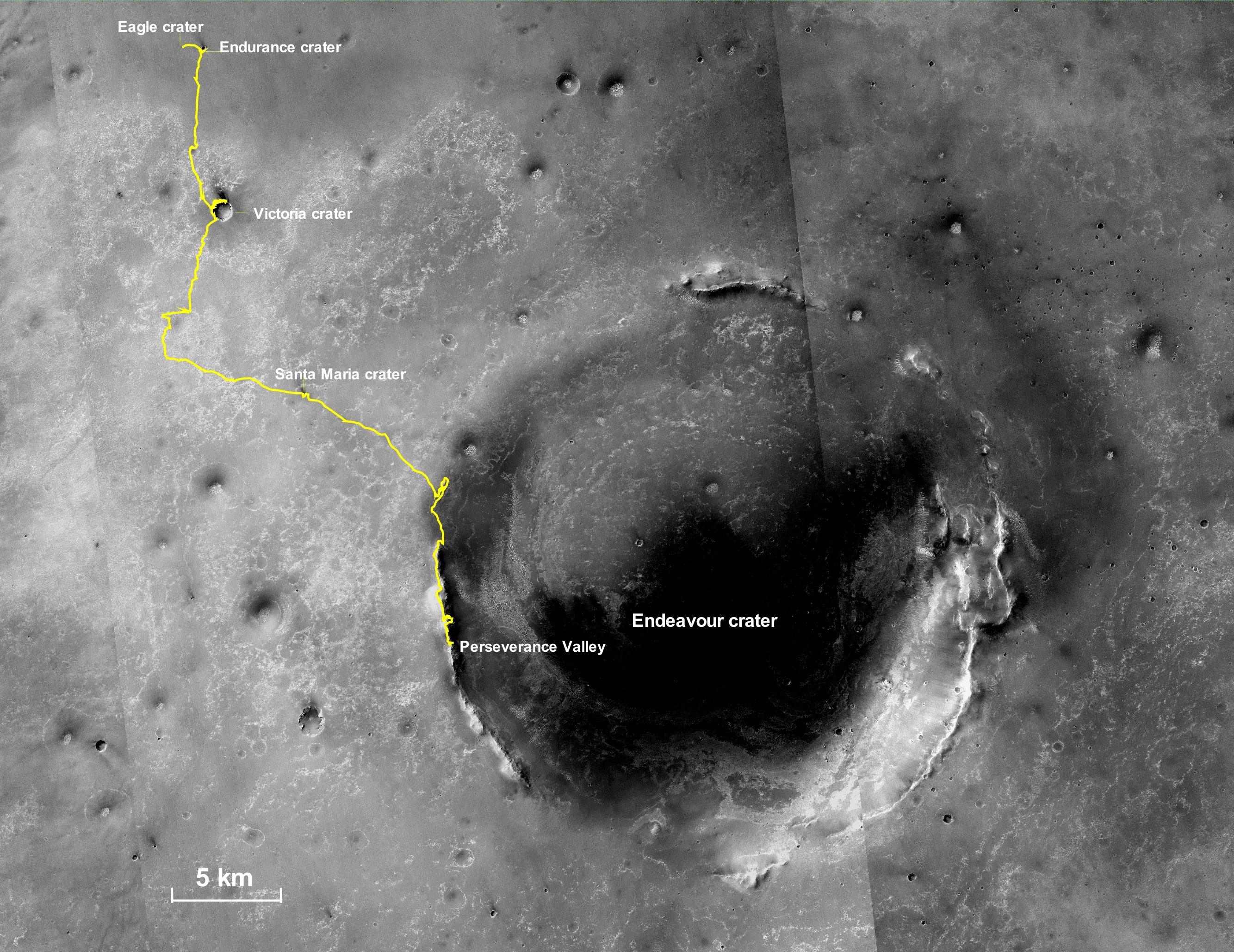
Opportunity’s Final Traverse Map
- Click the image above for a larger view
- Full-Res JPEG (2667 x 2058) (1.1 MB)
- Full-Res TIFF (2667 x 2058) (8.6 MB)
Caption:
This final traverse map for NASA's Opportunity rover shows where the rover was located within Perseverance Valley on June 10, 2018, the last date it made contact with its engineering team.
Visible in this map is a yellow traverse route beginning at Opportunity's landing site, Eagle Crater, and ranging 28.06 miles (45.16 kilometers) to its final resting spot on the rim of Endeavour Crater. The rover was descending down into the crater in Perseverance Valley when the dust storm ended its mission.
Background Info:
This map is made from several images taken by the Context Camera on NASA's Mars Reconnaissance Orbiter. Those images are: B02_010486_1779_XN_02S005W, P15_006847_1770_XN_03S005W, and P13_006135_1789_XN_01S005W. Malin Space Science Systems in San Diego built and operates the camera.
NASA's Jet Propulsion Laboratory, a division of Caltech in Pasadena, California, manages the Mars Exploration Rover and Mars Reconnaissance Orbiter projects for NASA's Science Mission Directorate, Washington.
Cataloging Keywords:
| Name | Value | Additional Values |
|---|---|---|
| Target | Mars | |
| System | ||
| Target Type | Planet | |
| Mission | Mars Reconnaissance Orbiter (MRO) | Mars 2020, Mars Exploration Rover (MER) |
| Instrument Host | Mars Reconnaissance Orbiter | Opportunity (MER-B), Perseverance |
| Host Type | Orbiter | Rover |
| Instrument | Context Camera (CTX) | |
| Detector | ||
| Extra Keywords | Atmosphere, Color, Crater, Dust, Map, Storm | |
| Acquisition Date | ||
| Release Date | 2019-04-25 | |
| Date in Caption | 2018-06-10 | |
| Image Credit | NASA/JPL-Caltech/MSSS | |
| Source | photojournal.jpl.nasa.gov/catalog/PIA23178 | |
| Identifier | PIA23178 | |
