
|
Barchan and Linear Dunes
- Click the image above for a larger view
- Full-Res JPEG (2880 x 1800) (944.9 kB)
- Full-Res TIFF (2880 x 1800) (14.8 MB)
Caption:

Map Projected Browse Image
Click on image for larger version
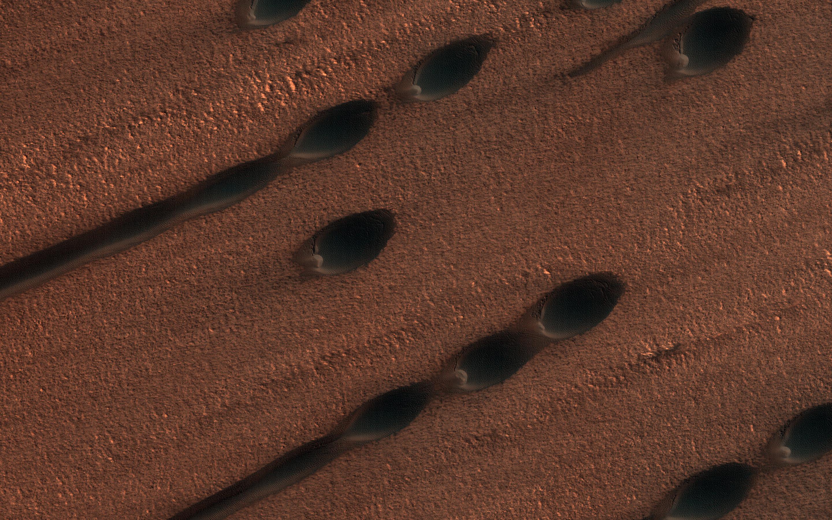
This image shows two types of sand dunes on Mars. The small dots are called barchan dunes, and from their shape we can tell that they are upwind. The downwind dunes are long and linear.
These two types of dune each show the wind direction in different ways: the barchans have a steep slope and crescent-shaped "horns" that point downwind, while the linear dunes are stretched out along the primary wind direction. Linear dunes, however, typically indicate a wind regime with at least two different prevailing winds, which stretch out the sand along their average direction.
In several places in this image, you can find barchan dunes turning into linear dunes as they are stretched out, but they both seem into indicate the same wind direction.
The map is projected here at a scale of 25 centimeters (9.8 inches) per pixel. (The original image scale is 32.0 centimeters [12.6 inches] per pixel [with 1 x 1 binning]; objects on the order of 96 centimeters [37.8 inches] across are resolved.) North is up.
Background Info:
The University of Arizona, in Tucson, operates HiRISE, which was built by Ball Aerospace & Technologies Corp., in Boulder, Colorado. NASA's Jet Propulsion Laboratory, a division of Caltech in Pasadena, California, manages the Mars Reconnaissance Orbiter Project for NASA's Science Mission Directorate, Washington.
Cataloging Keywords:
| Name | Value | Additional Values |
|---|---|---|
| Target | Mars | |
| System | ||
| Target Type | Planet | |
| Mission | Mars Reconnaissance Orbiter (MRO) | |
| Instrument Host | Mars Reconnaissance Orbiter | |
| Host Type | Orbiter | |
| Instrument | High Resolution Imaging Science Experiment (HiRISE) | |
| Detector | ||
| Extra Keywords | Color, Dune, Map | |
| Acquisition Date | ||
| Release Date | 2020-01-16 | |
| Date in Caption | ||
| Image Credit | NASA/JPL-Caltech/University of Arizona | |
| Source | photojournal.jpl.nasa.gov/catalog/PIA23669 | |
| Identifier | PIA23669 | |