|
Wind Erosion
- Click the image above for a larger view
- Full-Res JPEG (1370 x 2648) (386.2 kB)
- Full-Res TIFF (1370 x 2648) (2.8 MB)
Caption:
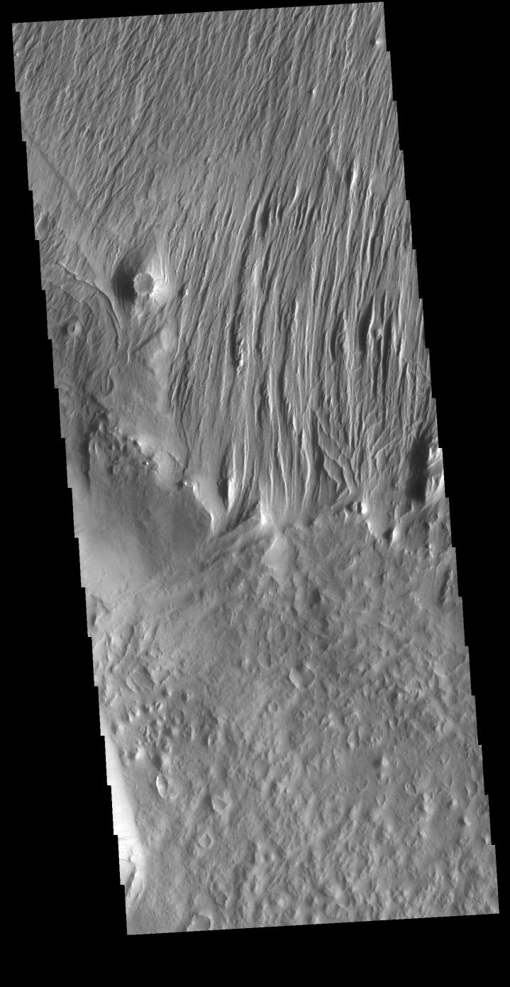
Context image
Located east of Eumenides Dorsum, this VIS image contains evidence of long term wind action and erosion. This area of Mars is dominated by poorly cemented surface material that is easily eroded by the wind. Unidirectional winds have created the linear ridge/valley system at the top half of this image. These features are called yardangs. Studies of this area propose volcanic ash eruptions from nearby volcanoes are the source of the surface material.
Orbit Number: 81078 Latitude: -2.2665 Longitude: 205.439 Instrument: VIS Captured: 2020-03-25 04:51
Background Info:
Please see the THEMIS Data Citation Note for details on crediting THEMIS images.
NASA's Jet Propulsion Laboratory manages the 2001 Mars Odyssey mission for NASA's Science Mission Directorate, Washington, D.C. The Thermal Emission Imaging System (THEMIS) was developed by Arizona State University, Tempe, in collaboration with Raytheon Santa Barbara Remote Sensing. The THEMIS investigation is led by Dr. Philip Christensen at Arizona State University. Lockheed Martin Astronautics, Denver, is the prime contractor for the Odyssey project, and developed and built the orbiter. Mission operations are conducted jointly from Lockheed Martin and from JPL, a division of the California Institute of Technology in Pasadena.
Cataloging Keywords:
| Name | Value | Additional Values |
|---|---|---|
| Target | Mars | |
| System | ||
| Target Type | Planet | |
| Mission | 2001 Mars Odyssey | |
| Instrument Host | Mars Odyssey | |
| Host Type | Orbiter | |
| Instrument | Thermal Emission Imaging System (THEMIS) | |
| Detector | ||
| Extra Keywords | Grayscale, Thermal, Volcano | |
| Acquisition Date | ||
| Release Date | 2020-05-21 | |
| Date in Caption | 2020-03-25 | |
| Image Credit | NASA/JPL-Caltech/ASU | |
| Source | photojournal.jpl.nasa.gov/catalog/PIA23929 | |
| Identifier | PIA23929 | |