
|
Mars Polar Lander NOT Found
- Click the image above for a larger view
- Full-Res JPEG (604 x 604) (40.9 kB)
- Full-Res TIFF (604 x 604) (365.4 kB)
Caption:
17 October 2005
Following the loss of Mars Polar Lander in December 1999, the MOC team began a 2-month intensive effort to acquire 1.5 meters per pixel (~5 feet per pixel) images of the landing ellipse, in hopes of spotting the lander and, perhaps, to provide additional insight as to its fate. Those search efforts were described in two previous Mars Global Surveyor (MGS) Mars Orbiter Camera (MOC) releases:
- PIA02353 : Mars Polar Lander: The Search Continues 24 January 2000
- PIA02349 : Mars Polar Lander: The Search Begins 21 December 1999 .
In addition, a later year 2000 release included the full MOC imagemosaic of the site obtained during the search:
- PIA02815 : South Polar Terrain in "3-D" 16 October 2000 .
Based upon the configuration of Mars Exploration Rovers Spirit (
PIA05248
) and Opportunity (
PIA05229
,
PIA05230,
PIA05231
), lander hardware observed from orbit by MOC in early 2004, we revisited the December 1999/January 2000 images of the Mars Polar Lander site. Earlier this year, we identified a location in images acquired in January 2000 that included features reminiscent of those that might be expected to exist at the location where the Mars Polar Lander reached the surface. Specifically, we identified a bright feature that resembled a parachute, and a dark area with a small, light-toned central spot that could be the location of the lander amid a dust-deflated area cleared by the lander's descent engines. This finding, alongwith a definitive image of the Viking 2 lander, was detailed in:
At the time of this identification in early 2005, the Mars Polar Lander landing ellipse was covered by seasonal carbon dioxide frost. As the frost began to sublime away and spring gave way to summer, we attempted to acquire an image of the candidate Mars Polar Lander site at a spatial resolution that is higher than we were able to achieve during the initial search in December 1999/January 2000. To obtain an image with an effective spatial resolution better than 1 meter per pixel, we used the cPROTO (compensated Pitch and ROll Targeted Observation) technique described and illustrated last year in:
- PIA06880 : cPROTO Views of Spirit's Rover Tracks and Athabasca Vallis Flood Features 27 September 2004 .
Hitting a specific target with the cPROTO technique is challenging, and often it takes 3-4 attempts before we hit. For the candidate Mars Polar Lander location, we made 6 attempts. The first was in April 2005, when the surface was still covered with frost -- that image was saturated white because of the frost. The next attempts were made after the frost had sublimed away -- these were made in July, August, and September 2005. We finally hit the candidate lander location on 27 September 2005.
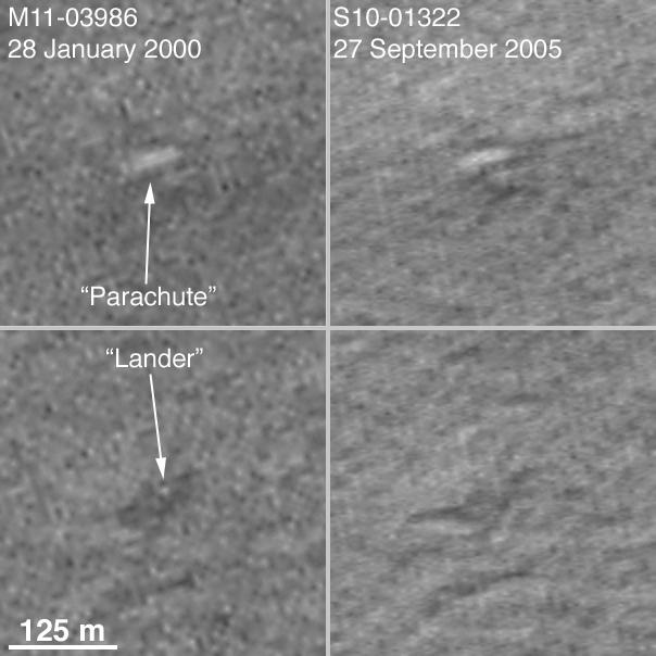
The figure above compares the features extracted from the earlier, January 2000, image with the same location seen in the new, September 2005, image. The two pictures were taken under nearly identical illumination and atmospheric conditions, almost exactly 3 Mars years apart. The feature identified as a candidate for Mars Polar Lander's parachute is found be the illuminated slope of a small hill. The hill is part of a group of similar hills in the area. The dark feature that was identified as possible rocket blast zone has faded (which would be expected owing to dust deposited by dust storms), but, more importantly, the spot interpreted to be the lander has disappeared. In reality, this spot is a pixel whose value differed from its neighbors in the first image owing to a bigger than average contribution of noise. Close inspection of the January 2000 image (bottom left) shows many small bright and dark blurry spots that do not show up in the September 2005 image (bottom right). There are even smaller, blurry spots in the second image, they are also noise. The fact that these pixels do not coincide is excellent evidence that they are not real features on the surface of Mars.
We conclude that our interpretation of these features was in error. This is NOT the location of the Mars Polar Lander. Because the landing uncertainty ellipse is so much larger than our images, and we do not have another candidate to which to target additional cPROTOs, we cannot continue to hunt for the lander. Finding it now falls to the High Resolution Imaging Science Experiment ( HiRISE ) presently en route to Mars on-board the Mars Reconnaissance Orbiter (MRO) spacecraft.
Location near
: 76.7°S, 195.3°W
The 125 meter scale bar
= ~ 410 feet
Illumination from
: upper left
Season
: Southern Summer (M11-03986 L
s
=291.5°; S10-01322 L
s
=295.7°)
Cataloging Keywords:
| Name | Value | Additional Values |
|---|---|---|
| Target | Mars | |
| System | ||
| Target Type | Planet | |
| Mission | Mars Global Surveyor (MGS) | Mars Exploration Rover (MER), Mars Reconnaissance Orbiter (MRO), Viking |
| Instrument Host | Mars Global Surveyor | Mars Reconnaissance Orbiter, Opportunity (MER-B), Spirit (MER-A), Viking 2 Lander |
| Host Type | Orbiter | Lander, Rover |
| Instrument | Mars Orbiter Camera (MOC) | |
| Detector | ||
| Extra Keywords | Atmosphere, Dust, Grayscale, Storm | |
| Acquisition Date | ||
| Release Date | 2005-10-17 | |
| Date in Caption | 1999-12-21 | 2000-01-24, 2000-10-16, 2004-09-27, 2005-05-05, 2005-09-27, 2005-10-17 |
| Image Credit | NASA/JPL/Malin Space Science Systems | |
| Source | photojournal.jpl.nasa.gov/catalog/PIA03044 | |
| Identifier | PIA03044 | |