
|
Enceladus’ Leading Hemisphere
- Click the image above for a larger view
- Full-Res JPEG (1900 x 1900) (261.2 kB)
- Full-Res TIFF (1900 x 1900) (3.6 MB)
Caption:
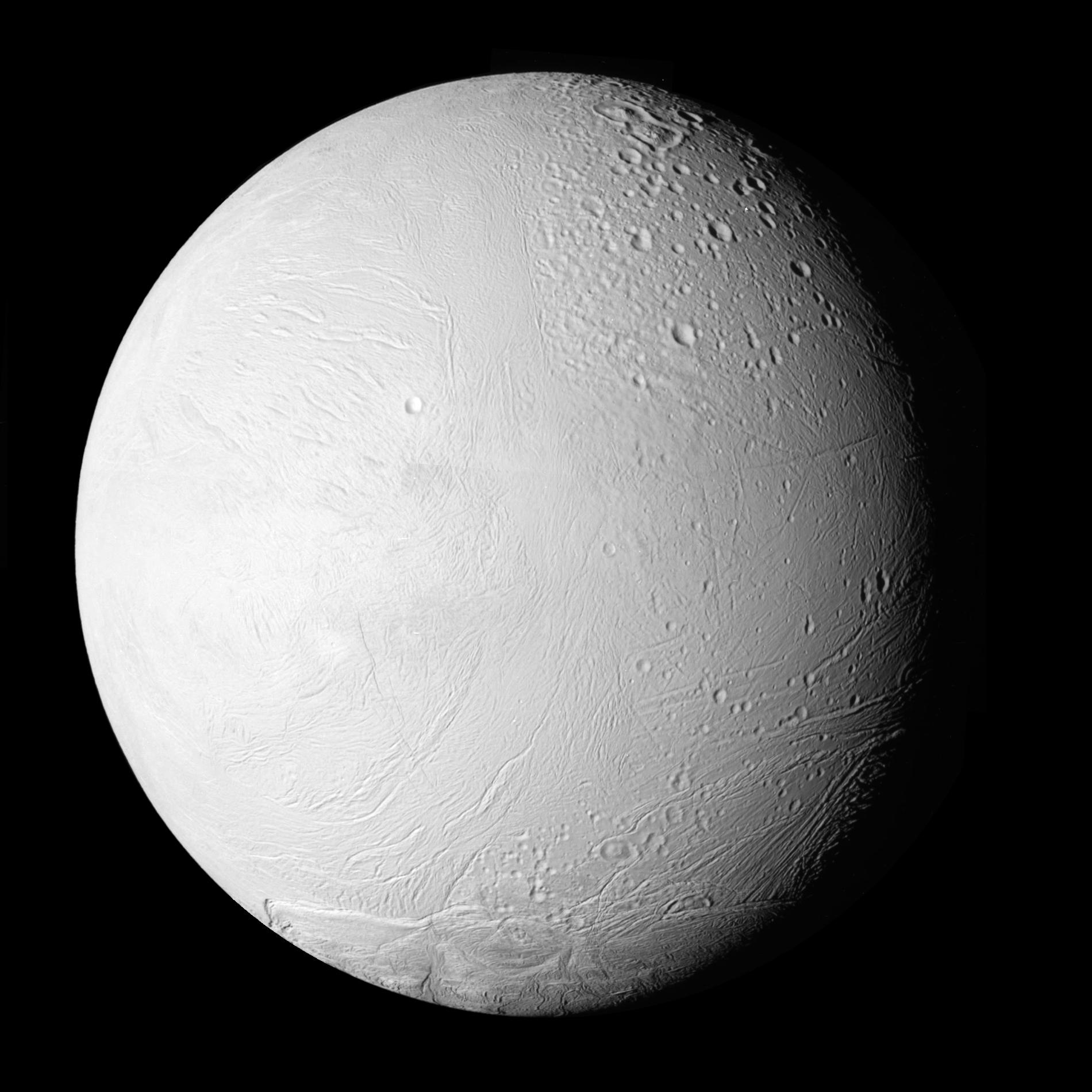
NASA's Cassini spacecraft shows a new view of Saturn's moon Enceladus in a whole-disk mosaic of the geologically active moon's leading, or western, hemisphere.
This map provides detailed coverage of the leading hemisphere of the moon in areas that previously had been imaged only with low resolution or in dim light. These new images, obtained at a low phase angle in which Enceladus is well lit by the sun, give Cassini scientists a much more nearly complete picture of the roughly circular symmetry of tectonic patterns around the leading hemisphere of the moon.
This map and an even higher resolution mosaic (see PIA11685 ) show the transition from the moon's more recently formed south polar terrain to older terrains to the north. This view emphasizes how a long, complex history of faulting has been focused and preserved in the leading hemisphere of Enceladus. Broad lanes of grooved terrains appear to encircle this hemisphere. These lanes enclose quasi-polygonal provinces of fractured, grooved, and striated plains of widely varying geological age. Heavily cratered terrain in the upper right of the image is the oldest. Less cratered terrain in the lower right is less old. Terrain on the left side of the image is younger, but that at the bottom is the youngest, most recently formed region.
This image and others like it from the close flyby of Enceladus on Nov. 21, 2009, are among the best visible light images Cassini will capture of the region around the "tiger stripes," the nickname for the fissures that spray icy particles, water vapor and organic compounds, before the moon's south polar region enters winter darkness for the coming years. Cassini scientists will use these new images to study geological activity associated with the tiger stripes and their effects on the surrounding terrain. This information, coupled with observations by Cassini's other instruments, will address the question of whether reservoirs of liquid water exist beneath the surface of the moon. See PIA11114 PIA11114 and PIA08386 to learn more.
This mosaic map was created from four images which were re-projected to an orthographic map projection. This image has not been cleaned of cosmic rays that struck the camera's sensor during exposure. These cosmic ray hits appear as small white streaks on the image.
This view looks toward the area between the leading hemisphere and the side of Enceladus facing Saturn. North on Enceladus (504 kilometers, 313 miles across) is up.
The images were taken in visible light with the Cassini spacecraft narrow-angle camera on Nov. 21, 2009. The view was acquired at a distance of approximately 53,000 kilometers (33,000 miles) from Enceladus and at a sun-Enceladus-spacecraft, or phase, angle of 35 degrees. Image scale is 307 meters (1,007 feet) per pixel.
Background Info:
The Cassini-Huygens mission is a cooperative project of NASA, the European Space Agency and the Italian Space Agency. The Jet Propulsion Laboratory, a division of the California Institute of Technology in Pasadena, manages the mission for NASA's Science Mission Directorate in Washington. The Cassini orbiter and its two onboard cameras were designed, developed and assembled at JPL. The imaging team is based at the Space Science Institute, Boulder, Colo.
For more information about the Cassini-Huygens mission visit http://saturn.jpl.nasa.gov/ . The Cassini imaging team homepage is at http://ciclops.org .
Cataloging Keywords:
| Name | Value | Additional Values |
|---|---|---|
| Target | Enceladus | Saturn |
| System | Saturn | |
| Target Type | Satellite | Planet |
| Mission | Cassini-Huygens | |
| Instrument Host | Cassini Orbiter | |
| Host Type | Orbiter | |
| Instrument | Imaging Science Subsystem (ISS) | |
| Detector | Narrow Angle Camera | |
| Extra Keywords | Crater, Grayscale, Map, Visual, Water | |
| Acquisition Date | ||
| Release Date | 2010-02-23 | |
| Date in Caption | 2009-11-21 | |
| Image Credit | NASA/JPL/Space Science Institute | |
| Source | photojournal.jpl.nasa.gov/catalog/PIA11684 | |
| Identifier | PIA11684 | |