|
Enceladus Sparkle
- Click the image above for a larger view
 Movie Download Options
- Full-Res JPEG (602 x 572) (90.9 kB)
- Full-Res TIFF (602 x 572) (1.0 MB)
Caption:
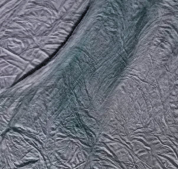
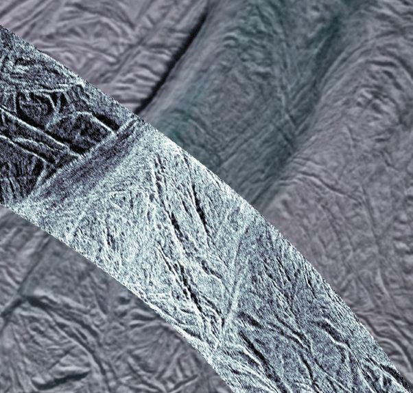
This image shows rough ice in the southern part of Saturn's moon Enceladus. It was created using synthetic-aperture radar (SAR) data acquired by NASA's Cassini spacecraft on Nov. 6, 2011. The SAR image is shown in light blue over a mosaic of lower-resolution images taken in visible light in 2006 ( PIA08342 ). The area imaged is a few hundred miles north of the vents from which water plumes have been previously detected ( PIA07758 ). The SAR image is centered on 63 degrees south latitude and 51 degrees west longitude. The new SAR swath is about 15.5 miles (25 kilometers) wide.
Data from the Cassini imaging instruments indicate that this area is composed of coarse-grain water ice. The brightness of the SAR data could indicate roughness of ice on the scale of the 1-inch (2-centimeter) radar wavelength or larger. The bright SAR image is reminiscent of surfaces known to be composed of rough or structured ice such as those of Europa, Mercury's pole and Earth's Greenland ice sheet, which supports this interpretation.
The SAR data are the highest resolution measurements made of this region of Enceladus. They also provide new information about the moon's surface, its topography and the top layers of the moon's crust. While both visible-light and SAR images reveal the shapes of surface features and give us information about their composition, SAR images add information about the roughness of the surface and its electrical nature. Electrical properties help scientists distinguish one material from another. Here, the higher resolution of the SAR images make it clear that the grooves fracture at their ends and form intricate patterns. The SAR image also reveals that the smaller grooves that enter this frame at upper left are cut off by this larger central feature, indicating that the bright central feature may be younger.
The grooves and fractures shown in this image cut through most of the southern region of Enceladus. Scientists think they have been produced by the extension, or pulling apart, of the moon's crust. The central, brighter fractured region bounded by two trenches that run from lower left to upper right is interpreted as terrain that has been heavily affected by tectonic processes. The two bounding trenches are large fractures with topographic scarps illuminated by the SAR.
Background Info:
The Cassini orbiter was designed, developed and assembled at JPL. The radar instrument was built by JPL and the Italian Space Agency (ASI), working with team members from the U.S. and several European countries. JPL is a division of the California Institute of Technology in Pasadena.
For more information about the Cassini-Huygens mission visit http://saturn.jpl.nasa.gov and http://www.nasa.gov/cassini . The Cassini imaging team homepage is at http://ciclops.org .
Cataloging Keywords:
| Name | Value | Additional Values |
|---|---|---|
| Target | Enceladus | Europa, Mercury |
| System | Saturn | Jupiter |
| Target Type | Satellite | Planet |
| Mission | Cassini-Huygens | |
| Instrument Host | Cassini Orbiter | |
| Host Type | Orbiter | |
| Instrument | Synthetic Aperture Radar (SAR) | |
| Detector | ||
| Extra Keywords | Color, Movie, Plume, Radar, Water | |
| Acquisition Date | ||
| Release Date | 2011-12-01 | |
| Date in Caption | 2011-11-06 | |
| Image Credit | NASA/JPL-Caltech/ASI/Space Science Institute | |
| Source | photojournal.jpl.nasa.gov/catalog/PIA15170 | |
| Identifier | PIA15170 | |